Hi Everybody!!
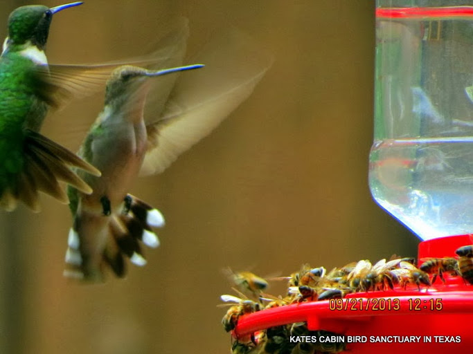
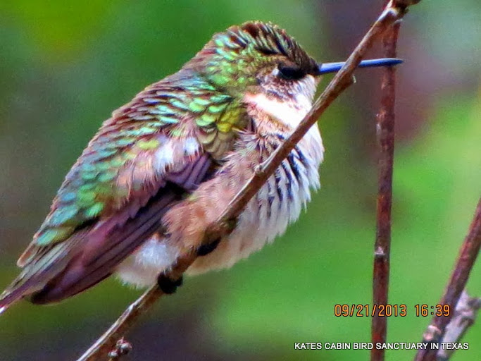
When the hummingbirds began to arrive it was Hot August and extreme drought. There were no flowers in the fields for the birds and bees, so they were very hungry when they got here. When they leave, it will be after a cold front has made its way south. It is like they "bring in Fall". On September 21, we had the first significant, measurable rainfall in 4 months. The new herd that came in last week, left for Mexico and took their bees with them! On the 22nd, I was feeling a little sad that some of the birds left. All of a sudden a butterfly showed up at the feeder! The first butterfly of fall. More birds will be coming in and all will stay until the cold front. Enjoy your photostudies-the links to the G+Albums are below:
20 Sept
link 1:
https://plus.google.com/u/0/photos/117645114459863049265/albums/5931137789065807489

21 Sept
link 2:
https://plus.google.com/u/0/photos/117645114459863049265/albums/5931139571423121697

21 Sept
link 3:
https://plus.google.com/u/0/photos/117645114459863049265/albums/5931143090509259793

22 Sept
link 4
https://plus.google.com/u/0/photos/117645114459863049265/albums/5931147727133806769

23 Sept
link 5:
https://plus.google.com/u/0/photos/117645114459863049265/albums/5931149889468517793

https://en.wikipedia.org/wiki/Cold_front
Cold front
From Wikipedia, the free encyclopedia
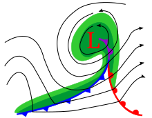
A cold front is defined as the leading edge of a cooler mass of air, replacing (at ground level) a warmer mass of air, which lies within a fairly sharp surface trough of low pressure. It forms in the wake of an extratropical cyclone, at the leading edge of its cold air advection pattern, which is also known as the cyclone's dry conveyor belt circulation. Temperature changes across the boundary can be as much as 30 °C(54 °F)[citation needed]. When enough moisture is present, rain can occur along the boundary. If there is significant instability along the boundary, a narrow line of thunderstorms can form along the frontal zone. If instability is less, a broad shield of rain can move in behind the front, which increases the temperature difference across the boundary. They are stronger in the fall and spring transition seasons, and weakest during the summer. When they catch up with the preceding warm front, the portion of the boundary which does so is then known as an occluded front.

Development of cold front[edit]
The cooler and denser air wedges under the less-dense warmer air, lifting it. This upward motion causes lowered pressure along the cold front and can cause the formation of a narrow line of showers and thunderstorms when enough moistureis present. On weather maps, the surface position of the cold front is marked with the symbol of a blue line of triangles/spikes (pips) pointing in the direction of travel. A cold front's location is at the leading edge of the temperature drop off, which in an isotherm analysis would show up as the leading edge of the isotherm gradient, and it normally lies within a sharp surface trough.[1] Cold fronts move faster than warm fronts and can produce sharper changes in weather. Since cold air is denser than warm air, it rapidly replaces the warm air preceding the boundary.[2]
In the northern hemisphere, a cold front usually causes a shift of wind from southwest to northwest clockwise, also known as veering, and in the southern hemisphere a shift from northeast to southwest, in a clockwise manner. Normally, cold fronts can be marked by these characteristics:
| Weather phenomenon | Prior to the Passing of the Front | While the Front is Passing | After the Passing of the Front |
|---|---|---|---|
| Temperature | Warm | Cooling suddenly | Steadily cooling |
| Atmospheric pressure | Decreasing steadily | Lowest, then sudden increase | Increasing steadily |
| Winds |
| Gusty; shifting |
|
| Precipitation/conditions* | Light patchy rain can be produced by stratocumulus or stratus in the warm sector. In summer, sometimes thunderstorms if a preceding squall line is present. | Prolonged rain (nimbostratus) orthunderstorms(cumulonimbus): depends on conditions. | Showers, then clearing |
| Clouds* | Often preceded by cirrus, cirrostratus then altostratus like a warm front (but usually with smaller amounts of these clouds). Areas of cirrocumulus and altocumulus within cirrostratus and altostratus more commonly seen than at a warm front. Larger cumulus clouds under the higher cloud types than at a warm front, where stratocumulus and cumulus humilis usually occur. Some of these cumulus clouds may produce showers ahead of the front. | Cumulonimbus and cumulus congestus producing frequent showers, with a sheet of upper altostratus, through which the sun can sometimes be seen. Less commonly nimbostratus occurs with continuous rain. | Patchy altocumulusor stratocumulus and higher cirrus clouds along with fast moving stratus fractus then eventually scatteredcumulus and sometimescumulonimbus. |
| Visibility* | Fair to poor in haze | Poor, but improving | Good, except in showers |
| Dew Point | High; steady | Sudden drop | Falling |
*Provided there is sufficient moisture.
Precipitation[edit]
A cold front commonly brings a narrow band of precipitation that follows along the leading edge of the cold front. These bands of precipitation are often very strong in nature,[3] and can bring severe thunderstorms, hailstorms and/ortornadoes. In the spring, these cold fronts can be very strong, and can bring strong winds when the pressure gradient is tighter than normal. During the winter months, cold fronts sometimes come through an area with little or no precipitation. Wider rain bands can occur behind cold fronts which tend to have more stratiform, and less convective, precipitation.[4] These rainstorms sometimes bring flooding, and can move very slowly when the storm steering it is strong and embedded within a meridional flow pattern (with more pole to equator motion rather than west to east motion). In the winter, cold fronts can bring cold spells, and occasionally snow. In the spring or summer in temperate latitudes, hail may occasionally fall along with the rain. If moisture is not sufficient, such as when a system has previously moved across a mountain barrier, cold fronts can pass without cloudiness.
Undercutting[edit]
The idea that cold air wedges, or undercuts, the warm air is often used to depict how advancing cold fronts force warm air to rise along the sloping cold air, much like a snow shovel scooping up snow,[5] creating instability. Provided with sufficient moisture, the rising air would thus condense, creating storms, clouds, and/or rain. While this concept is used to generally describe frontal precipitation patterns, it is technically incorrect.[6]
Frontogenetical Circulation[edit]
Frontogenesis is the process of creating or steepening the temperature gradient of a front. During this process the atmosphere reacts in an attempt to restore balance, the consequence is a circular motion along the front where air is being lifted up, along the cold front and dropping downward, behind the frontal boundary. This is the actual force of upward motion along a front that is responsible for clouds and precipitation.
As the temperature gradient steepens during frontogenesis, the thermal wind becomes imbalanced. To maintain balance, thegeostrophic wind aloft and below adjust, such that regions of divergence/convergence form. Mass continuity would require a vertical transport of air along the cold front where there is divergence (lowered pressure). Although this circulation is described by a series of processes, they are actually occurring at the same time, observable along the front as a thermally direct circulation. There are several factors that influence the final shape and tilt of the circulation around the front, ultimately determining the type and location of clouds and precipitation.[7][8]
Temperature changes[edit]
Cold fronts are the leading edge of cooler air masses, hence the name "cold front". They have stronger temperature changes during the fall (autumn) and spring and during the middle of winter. Temperature changes associated with cold fronts can be as much as 50F (30C). When cold fronts come through, there is usually a quick, yet strong gust of wind, that shows that the cold front is passing. In surface weather observations, a remark known as FROPA is coded when this occurs.[9] The effects from a cold front can last from hours to days. The air behind the front is cooler than the air it is replacing and the warm air is forced to rise, so it cools. As the cooler air can not hold as much moisture as warm air, clouds form and rain occurs.
Characteristics of boundaries around an extratropical cyclone[edit]
Cold fronts form when a cooler air mass moves into an area of warmer air in the wake of a developing extratropical cyclone. The warmer air interacts with the cooler air mass along the boundary, and usually produces precipitation. Cold fronts often follow a warm front or squall line. Very commonly, cold fronts have a warm front that is ahead of the cold front but with a perpendicular orientation. In areas where cold fronts catch up to the warm front, the occluded front develops. Occluded fronts have an area of warm air aloft. When such a feature forms poleward of an extratropical cyclone, it is known as a trowal, which is short for TRough Of Warm Air aLoft.[10] A cold front is considered a warm front if it begins to retreat ahead of the next extratropical cyclone along the frontal boundary, and called astationary front if it stalls.
Thanks to G+ Awesome Auto BackUp, here are some highlights from these albums!


...this is brendasue signing off from Rainbow Creek. See You next time! I hope You have been inspired to begin feeding birds! Love is contagious!

O+O


No comments:
Post a Comment
Hi Everybody! Please say hello and follow so I know you are here! Due to the inconsideration of people trying to put commercials on my blog comment area, I have restricted use of anonymous posts. Sorry that some hurt all.
My public email is katescabin@gmail.com No spammers or trolls