

Hi Everybody!!
So Do You know what a fire rainbow is?
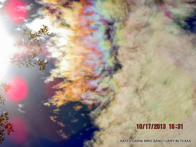
wow-We had some strange and beautiful clouds yesterday! Of course, I captured some to share with You. I am so surprised to see many other photos of the Atmospheric Optics (strange clouds) showing up everywhere on the local news stations and the Social Medias! I could not believe how many photos of this same cloud as mine. Now, do I suspect everyone in the world all of the sudden started photographing the rare sky events? No. I suggest that so many local news stations have joined Social Medias to connect with their viewers, that viewer weather photos are being seen by more people. To explain some of these rare sightings, I have shared excerpts from Wikipedia on Atmospheric Optics and Cicumhorizontal Arc.
(Please see links for complete articles) Enjoy!


https://en.wikipedia.org/wiki/Atmospheric_optics
Atmospheric optics
From Wikipedia, the free encyclopedia
Atmospheric optics deals with how the unique optical properties of theEarth's atmosphere cause a wide range of spectacular optical phenomena. The blue color of the sky is a direct result of Rayleigh scattering which redirects higher frequency (blue) sunlight back into the field of view of theobserver. Because blue light is scattered more easily than red light, the suntakes on a reddish hue when it is observed through a thick atmosphere, as during a sunrise or sunset. Additional particulate matter in the sky can scatter different colors at different angles creating colorful glowing skies at dusk and dawn. Scattering off of ice crystals and other particles in the atmosphere are responsible for halos, afterglows, coronas, rays of sunlight, and sun dogs. The variation in these kinds of phenomena is due to different particle sizes and geometries.[1]
Mirages are optical phenomena in which light rays are bent due to thermal variations in the refraction index of air, producing displaced or heavily distorted images of distant objects. Other optical phenomena associated with this include the Novaya Zemlya effect where the sun appears to rise earlier or set later than predicted with a distorted shape. A spectacular form of refraction occurs with a temperature inversion called the Fata Morgana where objects on the horizon or even beyond the horizon, such as islands, cliffs, ships or icebergs, appear elongated and elevated, like "fairy tale castles".[2]
Rainbows are the result of a combination of internal reflection and dispersive refraction of light in raindrops. Because rainbows are seen on the opposite side of the sky as the sun, rainbows are more prominent the closer the sun is to the horizon due to their greater distance apart.[3]

Cloud coloration[edit]
See also: Cloud


The color of a cloud, as seen from the Earth, tells much about what is going on inside the cloud. Dense deep tropospheric clouds exhibit a high reflectance (70% to 95%) throughout the visible spectrum. Tiny particles of water are densely packed and sunlight cannot penetrate far into the cloud before it is reflected out, giving a cloud its characteristic white color, especially when viewed from the top.[12] Cloud droplets tend to scatter light efficiently, so that the intensity of the solar radiationdecreases with depth into the gases. As a result, the cloud base can vary from a very light to very dark grey depending on the cloud's thickness and how much lightis being reflected or transmitted back to the observer. Thin clouds may look white or appear to have acquired the color of their environment or background. High tropospheric and non-tropospheric clouds appear mostly white if composed entirely of ice crystals and/or supercooled water droplets.
As a tropospheric cloud matures, the dense water droplets may combine to produce larger droplets, which may combine to form droplets large enough to fall as rain. By this process of accumulation, the space between droplets becomes increasingly larger, permitting light to penetrate farther into the cloud. If the cloud is sufficiently large and the droplets within are spaced far enough apart, it may be that a percentage of the light which enters the cloud is not reflected back out before it is absorbed. A simple example of this is being able to see farther in heavy rain than in heavy fog. This process of reflection/absorption is what causes the range of cloud color from white to black.[13]
Other colors occur naturally in clouds. Bluish-grey is the result of light scattering within the cloud. In the visible spectrum, blue and green are at the short end of light's visible wavelengths, while red and yellow are at the long end.[14] The short rays are more easily scattered by water droplets, and the long rays are more likely to be absorbed. The bluish color is evidence that such scattering is being produced by rain-sized droplets in the cloud. A greenish tinge to a cloud is produced when sunlight is scattered by ice. A cumulonimbus cloud emitting green is a sign that it is a severe thunderstorm,[15] capable of heavy rain, hail, strong winds and possibletornadoes. Yellowish clouds may occur in the late spring through early fall months during forest fire season. The yellow color is due to the presence of pollutants in the smoke. Yellowish clouds caused by the presence of nitrogen dioxide are sometimes seen in urban areas with high air pollution levels.[16]
Red, orange and pink clouds occur almost entirely at sunrise and sunset and are the result of the scattering of sunlight by the atmosphere. When the angle between the sun and the horizon is less than 10 percent, as it is just after sunrise or just prior to sunset, sunlight becomes too red due to refraction for any colors other than those with a reddish hue to be seen.[15] The clouds do not become that color; they are reflecting long and unscattered rays of sunlight, which are predominant at those hours. The effect is much like if one were to shine a red spotlight on a white sheet. In combination with large, mature thunderheads this can produce blood-red clouds. Clouds look darker in the near-infrared because water absorbs solar radiation at those wavelengths.
Sun dog[edit]

Main article: Sun dog
Sun dogs are made commonly of plate-shaped hexagonal ice crystals in high and cold cirrus clouds or, during very cold weather, by ice crystals called diamond dust drifting in the air at low levels.[22] Scientists at McMurdo Station frequently see sun dogs.[23] These crystals act as prisms, bending the light rays passing through them with a minimum deflection of 22°. If the crystals become vertically aligned as they sink through air, sunlight is refracted horizontally, which causes sundogs to be seen. Sun dogs can appear either as mirror images of the sun on either side of its actual location,[23] or as bright patches of light along partial halos horizontal to the sun's location.[22]
As the sun rises higher, the rays passing through the crystals are increasingly skewed from the horizontal plane. Their angle of deviation increases and the sundogs move further from the sun.[24] However, they always stay at the same elevation as the sun. Sun dogs are red-colored at the side nearest the sun. Farther out the colors grade to blue or violet.[22] However, the colors overlap considerably and so are muted, rarely pure or saturated. The colors of the sun dog finally merge into the white of the parhelic circle (if the latter is visible).
It is theoretically possible to predict the forms of sun dogs as would be seen on other planets and moons. Mars might have sundogs formed by both water-ice and CO2-ice. On the giant gas planets — Jupiter, Saturn, Uranus and Neptune — other crystals form the clouds of ammonia, methane, and other substances that can produce halos with four or more sundogs.[25]


https://en.wikipedia.org/wiki/Circumhorizontal_arc
Circumhorizontal arc
From Wikipedia, the free encyclopedia

A circumhorizontal arc is an optical phenomenon - an ice-halo formed by plate-shaped ice crystals in high level cirrus clouds.
Other currently accepted names for the phenomenon are circumhorizon arc or lower symmetric 46° plate arc.[1] The misleading term "fire rainbow" is sometimes used to describe these phenomena, although they are neither rainbows, nor related in any way to fire. The name comes from its appearance as a rainbow taking the shape of flames in the sky.[2][3]
The complete halo is a huge, multi-coloured band running parallel to the horizon with its centre beneath the sun. The distance below the sun is twice as far as the common 22-degree halo. Red is the uppermost colour. Often, when the halo-forming cloud is small or patchy, only fragments of the arc are seen.
How often a circumhorizontal arc is seen, depends on the location and the latitude of the observer. In the United States it is a relatively common halo seen several times each summer in any one place. In contrast, it is rare phenomenon in northern Europe for several reasons.
Formation of the halo requires that the sun be very high in the sky, at an elevation of 58° or greater, and that a cirrus cloud or haze be present and contain plate-shaped ice crystals. The sun's altitude determines the visibility of the halo; it is impossible to see at locations north of 55°N or south of 55°S (although a lunar circumhorizon arc might be visible at other latitudes). At other latitudes the phenomenon is visible, for a greater or lesser time, around the summer solstice. Slots of visibility for different latitudes and locations may be looked up here. For example, in London, England the sun is only high enough for 140 hours between mid-May and late July. Contrast that with Los Angeles, with the sun higher than 58 degrees for 670 hours between late March and late September.
The halo is formed by sunlight entering horizontally-oriented, flat, hexagon ice crystals through a vertical side face and leaving through the near horizontal bottom face (plate thickness does not affect the formation of the halo). In principle, Parry oriented column crystals may also produce the arc, although this is rare. The 90° inclination between the ray entrance and exit faces produce the well-separated spectral colours.
The arc has a considerable angular extent and thus, rarely is complete. When only fragments of a cirrus cloud are in the appropriate sky and sun position, they may appear to shine with spectral colours.[4]
A circumhorizontal arc may be difficult to distinguish from an infralateral arc when the sun is high in the sky. The former is always parallel to the horizon, whereas the latter curves upward at its ends.[4]

******New Feature: Your extended photostudy is located in my G+ Photo Albums at the link below. Click on the link to go see the pics. Then You click out and come back! (You are welcome to view all the albums You want and plus 1 the images you like for my end of the year best pics as I need some help on that project!!!)
Link to Strange Clouds Photostudy in my Album Gallery::
https://plus.google.com/photos/117645114459863049265/albums/5936299145669027265

...this is brendasue signing off from Rainbow Creek. See You next time!
Keep a wise eye to the sky and Your Camera ready!

O+O
No comments:
Post a Comment
Hi Everybody! Please say hello and follow so I know you are here! Due to the inconsideration of people trying to put commercials on my blog comment area, I have restricted use of anonymous posts. Sorry that some hurt all.
My public email is katescabin@gmail.com No spammers or trolls