Hi Everybody!!
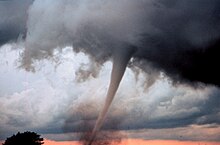
Today a March Wind came roaring into town! That north wind was howling through the trees. It was blue sky and sunshine so I was planting a few more flowers. As you know from my pics, my place is total trees! The wind pruned a few dead branches so I had to keep an eye looking up. I have well learned the sound of a branch snapping off and know to move quickly if I hear the Crack! The old proverb states: March Wind and April Showers make May Flowers. I shared info on the Wind for this windy day. I wonder how many of you are planting flowers? Try it, you might like it! Enjoy!


Bad Hair Day!

http://en.wikipedia.org/wiki/Wind
Wind
From Wikipedia, the free encyclopedia
Wind is the flow of gases on a large scale. On the surface of the Earth, wind consists of the bulk movement of air. In outer space, solar wind is the movement of gases or charged particles from the sun through space, while planetary wind is the outgassing of light chemical elements from a planet's atmosphere into space. Winds are commonly classified by their spatial scale, their speed, the types of forces that cause them, the regions in which they occur, and their effect. The strongest observed winds on a planet in our solar system occur on Neptune and Saturn. Winds have various aspect, one important aspect is its velocity; another the density of the gas involved; another is the energy content or wind energy of a wind.
In meteorology, winds are often referred to according to their strength, and the direction from which the wind is blowing. Short bursts of high speed wind are termed gusts. Strong winds of intermediate duration (around one minute) are termed squalls. Long-duration winds have various names associated with their average strength, such asbreeze, gale, storm, hurricane, and typhoon. Wind occurs on a range of scales, from thunderstorm flows lasting tens of minutes, to local breezes generated by heating of land surfaces and lasting a few hours, to global winds resulting from the difference in absorption of solar energy between the climate zones on Earth. The two main causes of large-scale atmospheric circulation are the differential heating between the equator and the poles, and the rotation of the planet (Coriolis effect). Within the tropics, thermal low circulations over terrain and high plateaus can drive monsoon circulations. In coastal areas the sea breeze/land breeze cycle can define local winds; in areas that have variable terrain, mountain and valley breezes can dominate local winds.
In human civilization, wind has inspired mythology, influenced the events of history, expanded the range of transport and warfare, and provided a power source formechanical work, electricity and recreation. Wind powers the voyages of sailing shipsacross Earth's oceans. Hot air balloons use the wind to take short trips, and powered flight uses it to increase lift and reduce fuel consumption. Areas of wind shear caused by various weather phenomena can lead to dangerous situations for aircraft. When winds become strong, trees and man-made structures are damaged or destroyed.
Winds can shape landforms, via a variety of aeolian processes such as the formation of fertile soils, such as loess, and by erosion. Dust from large deserts can be moved great distances from its source region by theprevailing winds; winds that are accelerated by rough topography and associated with dust outbreaks have been assigned regional names in various parts of the world because of their significant effects on those regions. Wind affects the spread of wildfires. Winds disperse seeds from various plants, enabling the survival and dispersal of those plant species, as well as flying insect populations. When combined with cold temperatures, wind has a negative impact on livestock. Wind affects animals' food stores, as well as their hunting and defensive strategies.
Cause[edit]
See also: Atmospheric pressure
Wind is caused by differences in atmospheric pressure. When a difference in atmospheric pressure exists, air moves from the higher to the lower pressure area, resulting in winds of various speeds. On a rotating planet, air will also be deflected by the Coriolis effect, except exactly on the equator. Globally, the two major driving factors of large-scale wind patterns (the atmospheric circulation) are the differential heating between the equator and the poles (difference in absorption of solar energy leading tobuoyancy forces) and the rotation of the planet. Outside the tropics and aloft from frictional effects of the surface, the large-scale winds tend to approach geostrophic balance. Near the Earth's surface, friction causes the wind to be slower than it would be otherwise. Surface friction also causes winds to blow more inward into low pressure areas.[1] A new, controversial theory, suggests atmospheric gradients are caused by forest induced water condensation resulting in a positive feedback cycle of forests drawing moist air from the coastline.[2]
Winds defined by an equilibrium of physical forces are used in the decomposition and analysis of wind profiles. They are useful for simplifying the atmospheric equations of motion and for making qualitative arguments about the horizontal and vertical distribution of winds. The geostrophic wind component is the result of the balance between Coriolis force and pressure gradient force. It flows parallel to isobars and approximates the flow above the atmospheric boundary layer in the midlatitudes.[3] Thethermal wind is the difference in the geostrophic wind between two levels in the atmosphere. It exists only in an atmosphere with horizontal temperature gradients.[4]The ageostrophic wind component is the difference between actual and geostrophic wind, which is responsible for air "filling up" cyclones over time.[5] The gradient wind is similar to the geostrophic wind but also includes centrifugal force (or centripetal acceleration).[6]
It is possible for wind to go in a downwards direction. This is known to cause serious injuries, in some cases death.[citation needed]
Measurement[edit]
Wind direction is usually expressed in terms of the direction from which it originates. For example, a northerly wind blows from the north to the south.[7] Weather vanes pivot to indicate the direction of the wind.[8] At airports, windsocks indicate wind direction, and can also be used to estimate wind speed by the angle of hang.[9] Wind speed is measured by anemometers, most commonly using rotating cups or propellers. When a high measurement frequency is needed (such as in research applications), wind can be measured by the propagation speed of ultrasound signals or by the effect of ventilation on the resistance of a heated wire.[10] Another type of anemometer uses pitot tubesthat take advantage of the pressure differential between an inner tube and an outer tube that is exposed to the wind to determine the dynamic pressure, which is then used to compute the wind speed.[11]
Sustained wind speeds are reported globally at a 10 meters (33 ft) height and are averaged over a 10 minute time frame. The United States reports winds over a 1 minute average for tropical cyclones,[12] and a 2 minute average within weather observations.[13] India typically reports winds over a 3 minute average.[14] Knowing the wind sampling average is important, as the value of a one-minute sustained wind is typically 14% greater than a ten-minute sustained wind.[15] A short burst of high speed wind is termed a wind gust, one technical definition of a wind gust is: the maxima that exceed the lowest wind speed measured during a ten-minute time interval by 10 knots (19 km/h). A squall is a doubling of the wind speed above a certain threshold, which lasts for a minute or more.
To determine winds aloft, rawinsondes determine wind speed by GPS, radio navigation, or radar tracking of the probe.[16] Alternatively, movement of the parent weather balloonposition can be tracked from the ground visually using theodolites.[17] Remote sensing techniques for wind include SODAR,Doppler LIDARs and RADARs, which can measure the Doppler shift of electromagnetic radiation scattered or reflected off suspended aerosols or molecules, and radiometers and radars can be used to measure the surface roughness of the ocean from space or airplanes. Ocean roughness can be used to estimate wind velocity close to the sea surface over oceans. Geostationary satellite imagery can be used to estimate the winds throughout the atmosphere based upon how far clouds move from one image to the next. Wind Engineering describes the study of the effects of the wind on the built environment, including buildings, bridges and other man-made objects.
Global climatology[edit]
Main article: Prevailing winds
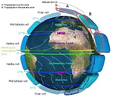
Easterly winds, on average, dominate the flow pattern across the poles, westerly winds blow across the mid-latitudes of the earth, polewards of the subtropical ridge, while easterlies again dominate the tropics.
Directly under the subtropical ridge are the doldrums, or horse latitudes, where winds are lighter. Many of the Earth's deserts lie near the average latitude of the subtropical ridge, where descent reduces the relative humidity of the air mass.[26] The strongest winds are in the mid-latitudes where cold polar air meets warm air from the tropics.
Tropics[edit]
See also: Trade wind and Monsoon
The trade winds (also called trades) are the prevailing pattern of easterly surface winds found in the tropics towards the Earth's equator.[27] The trade winds blow predominantly from the northeast in the Northern Hemisphere and from the southeast in the Southern Hemisphere.[28] The trade winds act as the steering flow for tropical cyclones that form over world's oceans.[29] Trade winds also steer African dust westward across theAtlantic Ocean into the Caribbean Sea, as well as portions of southeast North America.[30]
A monsoon is a seasonal prevailing wind that lasts for several months within tropical regions. The term was first used in English in India, Bangladesh, Pakistan, and neighboring countries to refer to the big seasonal winds blowing from the Indian Oceanand Arabian Sea in the southwest bringing heavy rainfall to the area.[31] Its poleward progression is accelerated by the development off a heat low over the Asian, African, and North American continents during May through July, and over Australia in December.[32][33][34]
Westerlies and their impact[edit]
Main article: Westerlies
The Westerlies or the Prevailing Westerlies are the prevailing winds in the middle latitudes between 35 and 65 degrees latitude. These prevailing winds blow from thewest to the east,[35][36] and steer extratropical cyclones in this general manner. The winds are predominantly from the southwest in the Northern Hemisphere and from the northwest in the Southern Hemisphere.[28] They are strongest in the winter when the pressure is lower over the poles, and weakest during the summer and when pressures are higher over the poles.[37]
Together with the trade winds, the westerlies enabled a round-trip trade route for sailing ships crossing the Atlantic and Pacific Oceans, as the westerlies lead to the development of strong ocean currents on the western sides of oceans in both hemispheres through the process of western intensification.[38] These western ocean currents transport warm, sub tropical water polewards toward the polar regions. The westerlies can be particularly strong, especially in the southern hemisphere, where there is less land in the middle latitudes to cause the flow pattern to amplify, which slows the winds down. The strongest westerly winds in the middle latitudes are within a band known as the Roaring Forties, between 40 and 50 degrees latitude south of the equator.[39] The Westerlies play an important role in carrying the warm, equatorial waters and winds to the western coasts of continents,[40][41] especially in the southern hemisphere because of its vast oceanic expanse.


...this is brendasue signing off from Rainbow Creek. See You next time!!

O+O


No comments:
Post a Comment
Hi Everybody! Please say hello and follow so I know you are here! Due to the inconsideration of people trying to put commercials on my blog comment area, I have restricted use of anonymous posts. Sorry that some hurt all.
My public email is katescabin@gmail.com No spammers or trolls