HI EVERYBODY!!
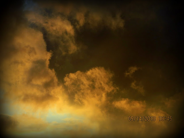
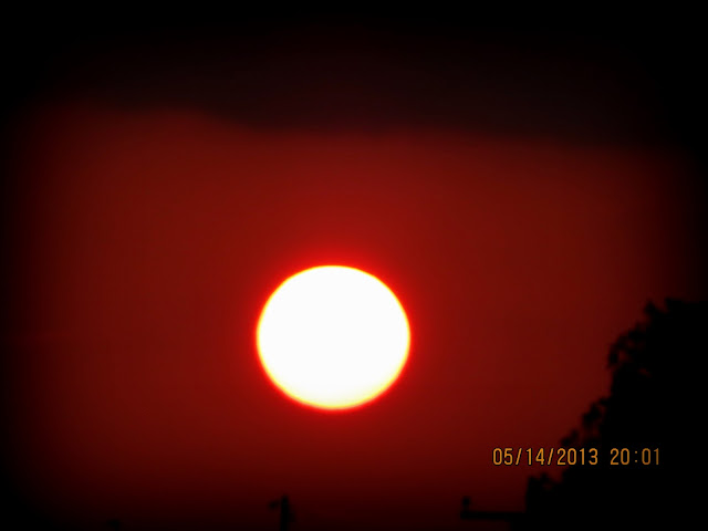
This is the time of year tornadoes make an appearance dancing across the land. Unfortunately, the States experience more events than any other Countries. On May 13, there were nasty storm clouds gathering around the sun as I headed into the Cafe for a snack. Thirty minutes later I walked out and saw the clouds had formed a tornado right over US 290. It did not touch down and began to explode and break apart right in front of my eyes. For review, I have enclosed the Wikipedia Page for tornadoes. Also, check the Google Index for updates on any current conditions. Your photostudy is the tornado and the incredible Sunset that survived. Enjoy!
News for tornado
At least 6 killed, over a dozen injured after tornado rips through North Texas town
Fox News - 1 hour agoThe tornado hit the scenic Brazos River courthouse town of Granbury about 8 p.m. Wednesday.
- USA TODAY - 1 hour ago
- ABC News - 37 minutes ago
https://en.wikipedia.org/wiki/Tornado
Tornado
From Wikipedia, the free encyclopedia
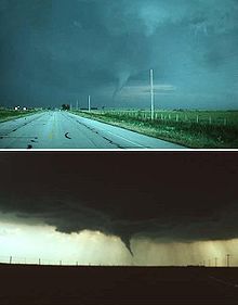
A tornado is a violently rotating column of air that is in contact with both the surface of the earth and a cumulonimbus cloud or, in rare cases, the base of a cumulus cloud. They are often referred to astwisters or cyclones,[1] although the word cyclone is used in meteorology, in a wider sense, to name any closed low pressure circulation. Tornadoes come in many shapes and sizes, but they are typically in the form of a visible condensation funnel, whose narrow end touches the earth and is often encircled by a cloud of debris and dust. Most tornadoes have wind speeds less than 110 miles per hour (177 km/h), are about 250 feet (76 m) across, and travel a few miles (several kilometers) before dissipating. The most extreme tornadoes can attain wind speeds of more than 300 miles per hour (483 km/h), stretch more than two miles (3.2 km) across, and stay on the ground for dozens of miles (more than 100 km).[2][3][4]
Various types of tornadoes include the landspout, multiple vortex tornado, and waterspout. Waterspouts are characterized by a spiraling funnel-shaped wind current, connecting to a large cumulus or cumulonimbus cloud. They are generally classified as non-supercellular tornadoes that develop over bodies of water, but there is disagreement over whether to classify them as true tornadoes. These spiraling columns of air frequently develop in tropical areas close to the equator, and are less common at high latitudes.[5] Other tornado-like phenomena that exist in nature include the gustnado, dust devil, fire whirls, and steam devil.
Tornadoes have been observed on every continent except Antarctica. However, the vast majority of tornadoes in the world occur in the Tornado Alley region of the United States, although they can occur nearly anywhere in North America.[6] They also occasionally occur in south-central and eastern Asia, northern and east-central South America, Southern Africa, northwestern and southeast Europe, western and southeastern Australia, and New Zealand.[7] Tornadoes can be detected before or as they occur through the use of Pulse-Doppler radar by recognizing patterns in velocity and reflectivity data, such as hook echoes, as well as by the efforts of storm spotters.
There are several scales for rating the strength of tornadoes. The Fujita scale rates tornadoes by damage caused and has been replaced in some countries by the updated Enhanced Fujita Scale. An F0 or EF0 tornado, the weakest category, damages trees, but not substantial structures. An F5 or EF5 tornado, the strongest category, rips buildings off their foundations and can deform largeskyscrapers. The similar TORRO scale ranges from a T0 for extremely weak tornadoes to T11 for the most powerful known tornadoes.[8] Doppler radar data, photogrammetry, and ground swirl patterns (cycloidal marks) may also be analyzed to determine intensity and assign a rating.[9]
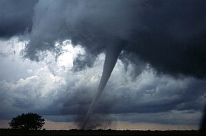
A tornado near Anadarko, Oklahoma. The funnel is the thin tube reaching from the cloud to the ground. The lower part of this tornado is surrounded by a translucent dust cloud, kicked up by the tornado's strong winds at the surface. The wind of the tornado has a much wider radius than the funnel itself.
Definitions
A tornado is "a violently rotating column of air, in contact with the ground, either pendant from a cumuliform cloudor underneath a cumuliform cloud, and often (but not always) visible as a funnel cloud".[14] For a vortex to be classified as a tornado, it must be in contact with both the ground and the cloud base. Scientists have not yet created a complete definition of the word; for example, there is disagreement as to whether separate touchdowns of the same funnel constitute separate tornadoes.[4] Tornado refers to the vortex of wind, not the condensation cloud.[15][16]
Funnel cloud
Main article: Funnel cloud
A tornado is not necessarily visible; however, the intense low pressure caused by the high wind speeds (as described by Bernoulli's principle) and rapid rotation (due to cyclostrophic balance) usually causes water vapor in the air to condense into cloud droplets due to adiabatic cooling. This results in the formation of a visible funnel cloud or condensation funnel.[17]
There is some disagreement over the definition of funnel cloud and condensation funnel. According to the Glossary of Meteorology, a funnel cloud is any rotating cloud pendant from a cumulus or cumulonimbus, and thus most tornadoes are included under this definition.[18] Among many meteorologists, the funnel cloud term is strictly defined as a rotating cloud which is not associated with strong winds at the surface, and condensation funnel is a broad term for any rotating cloud below a cumuliform cloud.[4]
Tornadoes often begin as funnel clouds with no associated strong winds at the surface, and not all funnel clouds evolve into tornadoes. Most tornadoes produce strong winds at the surface while the visible funnel is still above the ground, so it is difficult to discern the difference between a funnel cloud and a tornado from a distance.[4]
Outbreaks and families
Main articles: Tornado family, tornado outbreak, and tornado outbreak sequence
Occasionally, a single storm will produce more than one tornado, either simultaneously or in succession. Multiple tornadoes produced by the same storm cellare referred to as a "tornado family".[19] Several tornadoes are sometimes spawned from the same large-scale storm system. If there is no break in activity, this is considered a tornado outbreak (although the term "tornado outbreak" has various definitions). A period of several successive days with tornado outbreaks in the same general area (spawned by multiple weather systems) is a tornado outbreak sequence, occasionally called an extended tornado outbreak.[14][20][21]
Appearance
Tornadoes can have a wide range of colors, depending on the environment in which they form. Those that form in dry environments can be nearly invisible, marked only by swirling debris at the base of the funnel. Condensation funnels that pick up little or no debris can be gray to white. While traveling over a body of water (as a waterspout), tornadoes can turn very white or even blue. Slow-moving funnels, which ingest a considerable amount of debris and dirt, are usually darker, taking on the color of debris. Tornadoes in the Great Plains can turn red because of the reddish tint of the soil, and tornadoes in mountainous areas can travel over snow-covered ground, turning white.[22]
Lighting conditions are a major factor in the appearance of a tornado. A tornado which is "back-lit" (viewed with the sun behind it) appears very dark. The same tornado, viewed with the sun at the observer's back, may appear gray or brilliant white. Tornadoes which occur near the time of sunset can be many different colors, appearing in hues of yellow, orange, and pink.[12][28]
Dust kicked up by the winds of the parent thunderstorm, heavy rain and hail, and the darkness of night are all factors which can reduce the visibility of tornadoes. Tornadoes occurring in these conditions are especially dangerous, since only weather radar observations, or possibly the sound of an approaching tornado, serve as any warning to those in the storm's path. Most significant tornadoes form under the storm's updraft base, which is rain-free,[29] making them visible.[30] Also, most tornadoes occur in the late afternoon, when the bright sun can penetrate even the thickest clouds.[20] Night-time tornadoes are often illuminated by frequent lightning.
There is mounting evidence, including Doppler On Wheels mobile radar images and eyewitness accounts, that most tornadoes have a clear, calm center with extremely low pressure, akin to the eye of tropical cyclones. This area would be clear (possibly full of dust), have relatively light winds, and be very dark, since the light would be blocked[citation needed] by swirling debris on the outside of the tornado. Lightning is said to be the source of illumination for those who claim to have seen the interior of a tornado.[31][32][33]
Rotation
Tornadoes normally rotate cyclonically (when viewed from above, this is counterclockwise in the northern hemisphere and clockwise in the southern). While large-scale storms always rotate cyclonically due to the Coriolis effect, thunderstorms and tornadoes are so small that the direct influence of the Coriolis effect is unimportant, as indicated by their large Rossby numbers. Supercells and tornadoes rotate cyclonically in numerical simulations even when the Coriolis effect is neglected.[34][35] Low-level mesocyclones and tornadoes owe their rotation to complex processes within the supercell and ambient environment.[36]
Approximately 1 percent of tornadoes rotate in an anticyclonic direction in the northern hemisphere. Typically, systems as weak as landspouts and gustnadoes can rotate anticyclonically, and usually only those which form on the anticyclonic shear side of the descending rear flank downdraft in a cyclonic supercell.[37] On rare occasions, anticyclonic tornadoes form in association with the mesoanticyclone of an anticyclonic supercell, in the same manner as the typical cyclonic tornado, or as a companion tornado either as a satellite tornado or associated with anticyclonic eddies within a supercell.[38]
Sound and seismology
Tornadoes emit widely on the acoustics spectrum and the sounds are caused by multiple mechanisms. Various sounds of tornadoes have been reported, mostly related to familiar sounds for the witness and generally some variation of a whooshing roar. Popularly reported sounds include a freight train, rushing rapids or waterfall, a nearby jet engine, or combinations of these. Many tornadoes are not audible from much distance; the nature and propagation distance of the audible sound depends on atmospheric conditions and topography.
The winds of the tornado vortex and of constituent turbulent eddies, as well as airflow interaction with the surface and debris, contribute to the sounds. Funnel clouds also produce sounds. Funnel clouds and small tornadoes are reported as whistling, whining, humming, or the buzzing of innumerable bees or electricity, or more or less harmonic, whereas many tornadoes are reported as a continuous, deep rumbling, or an irregular sound of "noise".[39]
Since many tornadoes are audible only when very near, sound is not reliable warning of a tornado. Tornadoes are also not the only source of such sounds in severe thunderstorms; any strong, damaging wind, a severe hail volley, or continuous thunder in a thunderstorm may produce a roaring sound.[40]
Tornadoes also produce identifiable inaudible infrasonic signatures.[41]
Unlike audible signatures, tornadic signatures have been isolated; due to the long distance propagation of low-frequency sound, efforts are ongoing to develop tornado prediction and detection devices with additional value in understanding tornado morphology, dynamics, and creation.[42] Tornadoes also produce a detectable seismicsignature, and research continues on isolating it and understanding the process.[43]
Electromagnetic, lightning, and other effects
Tornadoes emit on the electromagnetic spectrum, with sferics and E-field effects detected.[42][44][45] There are observed correlations between tornadoes and patterns of lightning. Tornadic storms do not contain more lightning than other storms and some tornadic cells never produce lightning. More often than not, overall cloud-to-ground (CG) lightning activity decreases as a tornado reaches the surface and returns to the baseline level when the tornado lifts. In many cases, intense tornadoes and thunderstorms exhibit an increased and anomalous dominance of positive polarity CG discharges.[46] Electromagnetics and lightning have little or nothing to do directly with what drives tornadoes (tornadoes are basically a thermodynamic phenomenon), although there are likely connections with the storm and environment affecting both phenomena.
Luminosity has been reported in the past and is probably due to misidentification of external light sources such as lightning, city lights, and power flashesfrom broken lines, as internal sources are now uncommonly reported and are not known to ever have been recorded. In addition to winds, tornadoes also exhibit changes in atmospheric variables such as temperature, moisture, and pressure. For example, on June 24, 2003 near Manchester, South Dakota, a probe measured a 100 mbar (hPa) (2.95 inHg) pressure decrease. The pressure dropped gradually as the vortex approached then dropped extremely rapidly to 850 mbar (hPa) (25.10 inHg) in the core of the violent tornado before rising rapidly as the vortex moved away, resulting in a V-shape pressure trace. Temperature tends to decrease and moisture content to increase in the immediate vicinity of a tornado.[47]
Life cycle
Further information: Tornadogenesis
Supercell relationship
See also: Supercell
Tornadoes often develop from a class of thunderstorms known as supercells. Supercells contain mesocyclones, an area of organized rotation a few miles up in the atmosphere, usually 1–6 miles (2–10 km) across. Most intense tornadoes (EF3 to EF5 on the Enhanced Fujita Scale) develop from supercells. In addition to tornadoes, very heavy rain, frequent lightning, strong wind gusts, and hail are common in such storms.
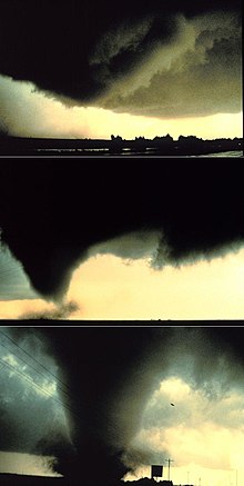
Most tornadoes from supercells follow a recognizable life cycle. That begins when increasing rainfall drags with it an area of quickly descending air known as the rear flank downdraft (RFD). This downdraft accelerates as it approaches the ground, and drags the supercell's rotating mesocyclone towards the ground with it.[15]
Formation
As the mesocyclone lowers below the cloud base, it begins to take in cool, moist air from the downdraft region of the storm. This convergence of warm air in the updraft, and this cool air, causes a rotating wall cloud to form. The RFD also focuses the mesocyclone's base, causing it to siphon air from a smaller and smaller area on the ground. As the updraft intensifies, it creates an area of low pressure at the surface. This pulls the focused mesocyclone down, in the form of a visible condensation funnel. As the funnel descends, the RFD also reaches the ground, creating a gust front that can cause severe damage a good distance from the tornado. Usually, the funnel cloud begins causing damage on the ground (becoming a tornado) within a few minutes of the RFD reaching the ground.[15]
Maturity
Initially, the tornado has a good source of warm, moist inflow to power it, so it grows until it reaches the "mature stage". This can last anywhere from a few minutes to more than an hour, and during that time a tornado often causes the most damage, and in rare cases can be more than one mile (1.6 km) across. Meanwhile, the RFD, now an area of cool surface winds, begins to wrap around the tornado, cutting off the inflow of warm air which feeds the tornado.[15]
Dissipation
As the RFD completely wraps around and chokes off the tornado's air supply, the vortex begins to weaken, and become thin and rope-like. This is the "dissipating stage"; often lasting no more than a few minutes, after which the tornado fizzles. During this stage the shape of the tornado becomes highly influenced by the winds of the parent storm, and can be blown into fantastic patterns.[20][27][28] Even though the tornado is dissipating, it is still capable of causing damage. The storm is contracting into a rope-like tube and, like the ice skater who pulls her arms in to spin faster, winds can increase at this point.[24]
As the tornado enters the dissipating stage, its associated mesocyclone often weakens as well, as the rear flank downdraft cuts off the inflow powering it. In particular, intense supercells tornadoes can develop cyclically. As the first mesocyclone and associated tornado dissipate, the storm's inflow may be concentrated into a new area closer to the center of the storm. If a new mesocyclone develops, the cycle may start again, producing one or more new tornadoes. Occasionally, the old (occluded) mesocyclone and the new mesocyclone produce a tornado at the same time.
Although this is a widely accepted theory for how most tornadoes form, live, and die, it does not explain the formation of smaller tornadoes, such as landspouts, long-lived tornadoes, or tornadoes with multiple vortices. These each have different mechanisms which influence their development—however, most tornadoes follow a pattern similar to this one.[48]
http://www.youtube.com/watch?v=H3iT_x9xA7Y
Published on May 13, 2013
Taken around 8 PM in Graz, Austria. The weather is 14°C with scattered clouds and 7 km/h wind blowing in from the East. Pressure is 1015 hPa and Humidity is at 36%.
"Effects of geomagnetic activity variations on the physiological and psychological state of functionally healthy humans: Some results of Azerbaijani studies" Authors: Elchin S. Babayev a,*, Aysel A. Allahverdiyeva b
A Couple of Pull Quotes:
"Negative influence of the geomagnetic field disturbances on human health is well displayed by the nervous system. Geomagnetic storms, as any stress factor, influence the functional state of humans & as such, impact the central nervous (the brain & spinal cord) system. This system behaves as a sensitive screen, perceiving even weak disturbance fluctuations (oscillations) in the environment (Baevsky, 1979 & Mikhailova, 2001)."
"Studies show (see, for example, the following papers and references therein: Breus and Rapoport, 2003; Palmer et al., 2006) that during periods of severe geomagnetic disturbances, number of hospitalized patients with nervous diseases significantly increases; cerebral insults, different paroxysmal conditions, nervous disturbance disorders and suicidal attempts are more frequent, and psycho-neurological diseases become aggravated."
Full Article Available Here:http://www.sciencedirect.com/science/...
I'd like to eventually get a dialogue going about what we feel and when; it's not the intensity of the events that necessarily matters, but the change to the pattern. Some of you hear it ringing in your ears, we could talk about that too. Ask me a question if you're interested, peace.
Some of S0s Transcripts: http://suspicious0bservers.tumblr.com/
Current Grazer Weather: http://www.wunderground.com/global/st...
EU Weather Alerts: http://www.meteoalarm.eu
Category
License
Standard YouTube License
...this is brendasue signing off from Rainbow Creek. See You next time. Big Hugs to All. Of course, one more great performance:
http://www.youtube.com/watch?v=pSajNLBH7cA
O+O









No comments:
Post a Comment
Hi Everybody! Please say hello and follow so I know you are here! Due to the inconsideration of people trying to put commercials on my blog comment area, I have restricted use of anonymous posts. Sorry that some hurt all.
My public email is katescabin@gmail.com No spammers or trolls