
Hi Everybody!!
Please Come in, take a break and consider the Nature of Reelfoot Lake.
In the 1800s, an Earthquake Event on the New Madrid Fault caused a chain reaction resulting in the formation of this lake where there had been no lake before! It is a very shallow lake, great for bluegill fishing. This is my favorite fish to cook and eat!!!!!
A bonus today before the photo study: A short little fishing trip to see this lake via You Tube Video. Enjoy!

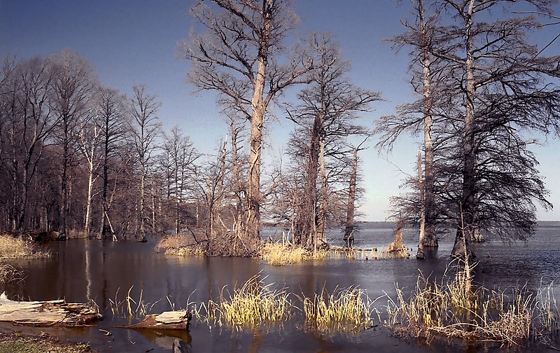
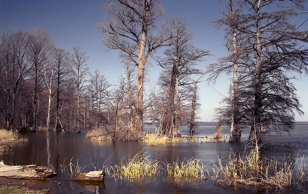
Reelfoot Lake is a shallow natural lake located in the northwest portion of Tennessee,United States of America. Much of it is really more of a swamp, with bayou-like ditches(some natural, some man-made) connecting more open bodies of water called basins, the largest of which is called Blue Basin. Reelfoot Lake is noted for its bald cypress trees and its nesting pairs of bald eagles. It is the site of Reelfoot Lake State Park. Lake Isom, a similar, smaller lake to the immediate south, is a National Wildlife Refuge area.
Reelfoot Lake
From Wikipedia, the free encyclopedia
History
According to the United States Geological Survey, Reelfoot Lake was formed when the region subsided during the New Madrid earthquakes of 1811–1812.[1] Several eyewitnesses[2] reported that the Mississippi River flowed backward for 10–24 hours to fill the lake. The earthquakes resulted in several major changes in the landforms over a widespread area with shocks being felt as far away asQuebec.
The name
Reelfoot Lake is said to be named for an Indian chief who had a deformed foot and was nicknamed "Reelfoot" by settlers in the early 1800s. A Chickasaw native American legend states that the name originated from a prince of a Chickasaw tribe inhabiting the presentWest Tennessee who was born with a deformed foot and walked with a rolling motion, so was nicknamed "Kolopin," meaning Reelfoot. When he became chief, Reelfoot determined to marry a Choctaw princess, but her father would not permit it. The Great Spirit warned Reelfoot that if he attempted to kidnap the maiden, his village and his people would be destroyed. Reelfoot disobeyed the Spirit, and seized the princess by force and carried her to Chickasaw territory, where he arranged a marriage ceremony. In the middle of the ceremony, the Great Spirit stamped his foot in anger, causing the earth to quake, and the Father of the Waters raised the Mississippi River over its banks, inundating Reelfoot's homeland. The water flowed into the imprint left by the Spirit's foot, forming a beautiful lake beneath which Reelfoot, his bride, and his people lie buried.
http://en.wikipedia.org/wiki/Reelfoot_Lake| Bluegill | |
|---|---|
 | |
| Scientific classification | |
| Kingdom: | Animalia |
| Phylum: | Chordata |
| Class: | Actinopterygii |
| Order: | Perciformes |
| Family: | Centrarchidae |
| Genus: | Lepomis |
| Species: | L. macrochirus |
http://www.youtube.com/watch?v=s8qeQ1_5gks
Uploaded by KYAfield on Jul 8, 2009
Earthquakes in 1811 left the mighty Mississippi flowing out of its historic channels. The result created a picturesque lake on the Kentucky Tennessee border. Fishing guide Billy Blakely tells the story of the geological events along the New Madrid fault line that lead to these pristine waters bursting with lily pads and Cyprus trees. Host Tim Farmer says that big bluegill the two were catching delivered quite a tremor of their own.

http://www.google.com/imgres?imgurl=http://www.fcps.edu/islandcreekes/ecology/Fish/Bluegill/bluegill4.jpg&imgrefurl=http://www.fcps.edu/islandcreekes/ecology/bluegill.htm&h=364&w=544&sz=32&tbnid=ONM3t28wyXioLM:&tbnh=90&tbnw=135&zoom=1&usg=__EWPx77TlA4aEyX0zwmm41vB-ReE=&docid=N_OU8LbD7KX4ZM&hl=en&sa=X&ei=HQ5iUJLZDYWpqgHz7IGYAg&sqi=2&ved=0CDMQ9QEwAw&dur=228
The following video is today's news by You Tube's Suspicious Observers. I try to share this news daily on the social medias as I like this effort. Short and to the point. Daily viewing is helping me understand all the space weather terms and a global view of Earth Updates.
Below his 3 minute vid is all the links he shares on his news. This is an excellent resource list you may want to copy and paste. I subscribed to this channel on You Tube, where you can see his other video creations.
link: http://www.youtube.com/user/Suspicious0bservers?feature=g-all-u
(Thank You, Suspicious Observers, for your News Breaks and all You do).
Just Push Play:
http://www.youtube.com/watch?v=I9CPHZHUq3Y
Published on Sep 25, 2012 by Suspicious0bservers
2012 Pole Shift Video: http://youtu.be/uI10tKuLtFU
TODAY'S LINKS
GOES14 Takes the Stage: http://www.nnvl.noaa.gov/MediaDetail2.php?MediaID=1195&MediaTypeID=1
Jupiter Explosion: http://phys.org/news/2012-09-explosion-jupiter.html
Arab Cyclones: http://phys.org/news/2012-09-tropical-cyclones-arabian-sea-due.html
Arctic Methane Mission: http://phys.org/news/2012-09-methane-gas-arctic-seafloor.html
Great Barrier Reef Climate Change: http://phys.org/news/2012-09-climate-great-barrier-reef.html
Grim Prediction: http://phys.org/news/2012-09-arctic-ice-cap.html
Europa Water: http://www.astrobio.net/pressrelease/5043/water-near-europas-surface-doesnt-s...
REPEAT LINKS
Spaceweather: http://spaceweather.com/ [Look on the left at the X-ray Flux and Solar Wind Speed/Density]
HAARP: http://www.haarp.alaska.edu/haarp/data.html [Click online data, and have a little fun]
SDO: http://sdo.gsfc.nasa.gov/data/ [Place to find Solar Images and Videos - as seen from earth]
SOHO: http://sohodata.nascom.nasa.gov/cgi-bin/soho_movie_theater [SOHO; Lasco and EIT - as seen from earth]
Stereo: http://stereo.gsfc.nasa.gov/cgi-bin/images [Stereo; Cor, EUVI, HI - as seen from the side]
SunAEON:http://www.sunaeon.com/#/solarsystem/ [Just click it... trust me]
SOLARIMG: http://solarimg.org/artis/ [All purpose data viewing site]
iSWA: http://iswa.gsfc.nasa.gov/iswa/iSWA.html [Free Application; for advanced sun watchers]
NASA ENLIL SPIRAL:http://iswa.gsfc.nasa.gov:8080/IswaSystemWebApp/iSWACygnetStreamer?timestamp=...
NOAA ENLIL SPIRAL: http://www.swpc.noaa.gov/wsa-enlil/
US Wind Map: http://hint.fm/wind/
NOAA Bouys: http://www.ndbc.noaa.gov/
NOAA Environmental Visualization Laboratory:http://www.nnvl.noaa.gov/Default.php
RSOE: http://hisz.rsoe.hu/alertmap/index2.php [That cool alert map I use]
GOES Xray: http://www.swpc.noaa.gov/sxi/goes15/index.html
JAPAN Radiation Map: http://jciv.iidj.net/map/
LISS: http://earthquake.usgs.gov/monitoring/operations/heliplots_gsn.php
Gamma Ray Bursts: http://grb.sonoma.edu/ [Really? You can't figure out what this one is for?]
BARTOL Cosmic Rays:http://neutronm.bartol.udel.edu//spaceweather/welcome.html [Top left box, look for BIG blue circles]
TORCON: http://www.weather.com/news/tornado-torcon-index [Tornado Forecast for the day]
GOES Weather: http://rsd.gsfc.nasa.gov/goes/ [Clouds over America]
RAIN RECORDS:http://www.cocorahs.org/ViewData/ListIntensePrecipReports.aspx
EL DORADO WORLD WEATHER MAP:http://www.eldoradocountyweather.com/satellite/ssec/world/world-composite-ir-...
PRESSURE MAP: http://www.woweather.com/cgi-bin/expertcharts?LANG=us&MENU=0000000000&...
HURRICANE TRACKER:http://www.weather.com/weather/hurricanecentral/tracker
INTELLICAST: http://www.intellicast.com/ [Weather site used by many youtubers]
NASA News: http://science.nasa.gov/science-news/science-at-nasa/
PHYSORG: http://phys.org/ [GREAT News Site!]
QUAKES LIST FULL: http://www.emsc-csem.org/Earthquake/seismologist.php
Always Check the Foreign News Sources as well!!!
Iran: Mehr News, TehranTimes
China: Xinhua, China.org, Chinadaily
Asia Times dot Com
Russia: Ria Novosti
Israel: Jerusalem Post, Israel National News, Haaretz
M/E: ArabNews, AlJazeera
Next is a one minute vid by another one of my favorite 'real-time' earth events video creator, Mr MBB333. I am subscribed to his You Tube Channel also. link: http://www.youtube.com/user/mrmbb333?feature=results_main
Just Push Play:
http://www.youtube.com/watch?v=dAMNCMIrOao
Published on Sep 23, 2012 by MrMBB333
SWP Charts show large cosmic rays detected, 9/23/2012.
http://neutronm.bartol.udel.edu//spaceweather/welcome.html
http://neutronm.bartol.udel.edu//spaceweather/welcome.html

New Madrid Seismic Zone
From Wikipedia, the free encyclopedia
The New Madrid Seismic Zone (pronounced/njuː ˈmædrɪd/), sometimes called the New Madrid Fault Line, is a major seismic zone and a prolific source of intraplate earthquakes (earthquakes within a tectonic plate) in the southern and midwestern United States, stretching to the southwest fromNew Madrid, Missouri.
The New Madrid fault system was responsible for the 1811–1812 New Madrid earthquakes and may have the potential to produce large earthquakes in the future. Since 1812 frequent smaller earthquakes were recorded in the area.[1]
Earthquakes that occur in the New Madrid Seismic Zone potentially threaten parts of seven American states: Illinois, Indiana, Missouri, Arkansas,Kentucky, Tennessee and Mississippi.[2]

Reelfoot Rift and the New Madrid Seismic Zone in a 3D topographic image
Magnetic potential map of the Reelfoot Rift
Geographic extent
The 150-mile (240 km) long fault system, which extends into five states, stretches southward from Cairo, Illinois; through Hayti,Caruthersville and New Madrid in Missouri; through Blytheville into Marked Tree in Arkansas. It also covers a part of West Tennessee, near Reelfoot Lake, extending southeast into Dyersburg.
Most of the seismicity is located between 3 and 15 miles (4.8 and 24 km) beneath the Earth's surface.
[edit]Earthquake history
The zone had four of the largest North American earthquakes in recorded history, with moment magnitudes estimated to be as large as 8.0, all occurring within a three-month period between December 1811 and February 1812. Many of the published accounts describe the cumulative effects of all the earthquakes (known as the New Madrid Sequence); thus finding the individual effects of each quake can be difficult. Magnitude estimates and epicenters are based on interpretations of historical accounts and may vary.
[edit]Prehistoric earthquakes
Because uplift rates associated with large New Madrid earthquakes could not have occurred continuously over geological timescales without dramatically altering the local topography, studies have concluded that the seismic activity there can not have gone on for longer than 64,000 years, making the NMSZ a young feature, or earthquakes and the associated uplift migrate around the area over time, or that the NMSZ has short periods of activity interspersed with long periods of quiet.[3] Archeological studies have found from studies ofsand blows and soil horizons that previous series of very large earthquakes have occurred in the NMSZ in recent prehistory. Based on artifacts found buried by sand blow deposits and from carbon-14 studies, previous large earthquakes like those of 1811–1812 appear to have happened around AD 1450 and around AD 900,[4] as well as approximately AD 300. Evidence has been found for an apparent series of large earthquakes around 2350 BC.[5] About 80 km southwest of the presently-defined NMSZ but close enough to be associated with the Reelfoot Rift, near Marianna, Arkansas, two sets of liquefaction features indicative of large earthquakes have been tentatively identified and dated to 3500 B.C. and 4800 B.C. These features were interpreted to have been caused by groups of large earthquakes timed closely together.[6]
Dendrochronology (tree ring) studies conducted on the oldest bald cypress trees growing in Reelfoot Lake found evidence of the 1811–1812 series in the form of fractures followed by rapid growth after their inundation, whereas cores taken from old bald cypress trees in the St. Francis sunklands showed slowed growth in the half century that followed 1812. These were interpreted as clear signals of the 1811–1812 earthquake series in tree rings. Because the tree ring record in Reelfoot Lake and the St. Francis sunklands extend back to A.D. 1682 and A.D. 1321, respectively, Van Arsdale et al. interpreted the lack of similar signals elsewhere in the chronology as evidence against large New Madrid earthquakes between those years and 1811.[7]
[edit]December 25, 1699
The first known written record of an earthquake felt in the NMSZ was from a French missionary traveling up the Mississippi with a party of explorers. At 1 PM, on Christmas Day 1699, at a site near the present-day location of Memphis, the party was startled by a short period of ground shaking.[8]

[edit]1811–1812 earthquake series
Main article: 1812 New Madrid earthquake
- December 16, 1811, 0815 UTC (2:15 a.m.); (M ~7.2 – 8.2[9]) epicenter in northeast Arkansas; it caused only slight damage to man-made structures, mainly because of the sparse population in the epicentral area. The future location of Memphis, Tennessee was shaken at Mercalli level nine intensity. A seismic seiche propagated upriver and Little Prairie was destroyed by liquefaction.[10] Local uplifts of the ground and water waves moving upstream gave the illusion that the river was flowing upstream.[11]
At New Madrid, trees were knocked down and riverbanks collapsed. This event shook windows and furniture in Washington, D.C., rang bells in Richmond, Virginia, sloshed well water and shook houses in Charleston, South Carolina, and knocked plaster off of houses in Columbia, South Carolina. In Jefferson, Indiana, furniture moved and in Lebanon, Ohio, residents fled their homes. Observers in Herculaneum, Missouri, called it "severe" and claimed it had a duration of 10–12 minutes.[12]
Aftershocks were felt every six to ten minutes, a total of 27, in New Madrid until what was called the Daylight Shock, which was of the same intensity as the first. Many of these were also felt throughout the eastern US, though with less intensity than the initial earthquake.[13]
- December 16, 1811, the Daylight Shock, 1415 UTC (8:15 a.m.); (M ~7.2 – 8.2) epicenter in northeast Arkansas; This shock followed the first earthquake by six hours and was similar in intensity.[9]
- January 23, 1812, 1500 UTC (9 a.m.); (M ~7.0 – 8.0[9]) epicenter in the Missouri Bootheel. The meizoseismal area was characterized by general ground warping, ejections, fissuring, severe landslides, and caving of stream banks. Johnston and Schweig attributed this earthquake to a rupture on the New Madrid North Fault. This may have placed strain on the Reelfoot Fault.[10]
- February 7, 1812, 0945 UTC (4:45 a.m.); (M ~7.4 – 8.6[9]) epicenter near New Madrid, Missouri. New Madrid was destroyed. At St. Louis, Missouri, many houses were severely damaged, and their chimneys were toppled. This shock was definitively attributed to the Reelfoot Fault by Johnston and Schweig. It was uplift along this reverse fault segment, in this event, that created waterfalls on theMississippi River, disrupted the Mississippi River at Kentucky Bend, created a wave that propagated upstream and caused the formation of Reelfoot Lake.[10]

The earthquakes were felt as far away as New York City and Boston, Massachusetts, where ground motion caused church bells to ring.[14]
Hundreds of aftershocks followed over a period of several years. Aftershocks strong enough to be felt occurred until the year 1817. The largest earthquakes to have occurred since then were on January 4, 1843, and October 31, 1895, with magnitude estimates of 6.0 and 6.6 respectively.
[edit]Modern activity
The biggest quake since 1811–1812 was a 6.6-magnitude quake on October 31, 1895, with an epicenter at Charleston, Missouri. The quake damaged virtually all buildings in Charleston, creating sand volcanoes by the city, cracked a pier on the Cairo Rail Bridgeand toppled chimneys in St. Louis, Missouri, Memphis, Tennessee, Gadsden, Alabamaand Evansville, Indiana.[15]
The next biggest quake was a 5.4-magnitude quake (although it was reported as a 5.5 at the time) on November 9, 1968, near Dale, Illinois. The quake damaged the civic building at Henderson, Kentucky and was felt in 23 states. People in Boston said their building swayed. It is the biggest recorded quake with an epicenter in Illinois in that state's recorded history.[16]
Instruments were installed in and around the area in 1974 to closely monitor seismic activity. Since then, more than 4,000 earthquakes have been recorded, most of which were too small to be felt. On average, one earthquake per year is large enough to be felt in the area.
[edit]Geology

The New Madrid Seismic Zone is made up of reactivated faults that formed when what is now North America began to split or rift apart during the breakup of thesupercontinent Rodinia in the Neoproterozoic Era (about 750 million years ago). Faults were created along the rift and igneous rocks formed from magma that was being pushed towards the surface. The resulting rift system failed but has remained as an aulacogen (a scar or zone of weakness) deep underground. Another unsuccessful attempt at rifting 200 million years ago created additional faults, which made the area weaker. The resulting geological structures make up the Reelfoot Rift, and have since been deeply buried by younger sediments. But the ancient faults appear to have made the rocks deep in the Earth's crust in the New Madrid area mechanically weaker than much of the rest of North America.
This weakness, possibly combined with focusing effects from mechanically stronger igneous rocks nearby, allows the relatively small east-west compressive forces that exist in the North American plate to reactivate old faults, making the area prone to earthquakes.[17]
Since other rifts are known to occur in North America's stress environment but not all are associated with modern earthquakes, (for example the Midcontinent Rift System that stretches from Minnesota to Kansas), other processes could be at work to locally increase mechanical stress on the New Madrid faults. Stress changes associated with bending of the lithosphere caused by the melting of continental glaciers at the end of the last Ice Age, has been considered to play a role,[18] as well as downward pull from sinking igneous rock bodies below the fault.[19] It has also been suggested that some form of heating in the lithosphere below the area may be making deep rocks more plastic, which concentrates compressive stress in the shallower subsurface area where the faulting occurs.[20] There may be local stress from a change in the flow of the mantle beneath the NMSZ, caused by the sinking Farallon Plate, according to one model.[21]
When epicenters of modern earthquakes are plotted on a map, three trends become apparent. First is the general northeast-southwest trend paralleling the trend of the Reelfoot Rift, in Arkansas, south of where the epicenters turn northwest. This is a right-lateral strike-slip fault system parallel to the Reelfoot Rift.
The second is the southeast to northwest trend that occurs just southwest of New Madrid. This trend is a stepover thrust fault known as the Reelfoot Fault, associated with the Tiptonville dome and the impoundment of Reelfoot Lake. Epicenter locations on this fault are more spread out because the fault surface is inclined and dips into the ground, towards the south, at around forty degrees. Slip is towards the northeast. Motion on this fault in the 1811–1812 series created waterfalls on the Mississippi.
The third trend, extending northeast from the northwestern end of the Reelfoot Fault is another right-lateral strike-slip fault known as New Madrid North.

[edit]Potential for future earthquakes
In a report filed in November 2008, The U.S. Federal Emergency Management Agency warned that a serious earthquake in the New Madrid Seismic Zone could result in "the highest economic losses due to a natural disaster in the United States," further predicting "widespread and catastrophic" damage across Alabama, Arkansas, Illinois, Indiana, Kansas, Kentucky, Mississippi, Missouri, Oklahoma, Texas, and particularly Tennessee, where a 7.7 magnitude quake or greater would cause damage to tens of thousands of structures affecting water distribution,transportation systems, and other vital infrastructure.[22] The earthquake is expected to also result in many thousands of fatalities, with more than 4,000 of the fatalities expected in Memphis alone.
The potential for the recurrence of large earthquakes and their impact today on densely populated cities in and around the seismic zone has generated much research devoted to understanding in the New Madrid Seismic Zone. By studying evidence of past quakes and closely monitoring ground motion and current earthquake activity, scientists attempt to understand their causes and recurrence intervals.
In October 2009, a team composed of University of Illinois and Virginia Tech researchers headed by Amr S. Elnashai, funded by FEMA, considered a scenario where all three segments of the New Madrid fault ruptured simultaneously. The report found that there would be significant damage in the eight states studied – Alabama, Arkansas, Illinois, Indiana, Kentucky, Mississippi, Missouri and Tennessee – with the probability of additional damage in states farther from the NMSZ. Tennessee, Arkansas, and Missouri would be most severely impacted, and the cities of Memphis, Tennessee and St. Louis, Missouri would be severely damaged. The report estimated 86,000 casualties, including 3,500 fatalities; 715,000 damaged buildings; and 7.2 million people displaced, with 2 million of those seeking shelter, primarily due to the lack of utility services. Direct economic losses, according to the report, would be at least $300 billion.[23]
[edit]Iben Browning's 1990 prediction
Beginning in February 1989, climatologist Iben Browning – who claimed to have predicted the 1980 eruption of Mount St. Helens, and the 1989 Loma Prieta earthquake a week in advance (for which some give him credit) – predicted that there was a 50 percent probability of a magnitude 6.5 to 7.5 earthquake in the New Madrid area sometime between December 1 and December 5, 1990.[24][25] The United States Geological Survey requested an evaluation of the prediction by an advisory board of earth scientists, who concluded that "the prediction does not have scientific validity."[25] Despite the lack of scientific support, Browning's prediction was widely reported in international media, causing public alarm. The period passed with no major earthquake activity in New Madrid or along the 120-mile (190 km) fault line.[25]
[edit]Uncertainty over potential for recurrence
The lack of apparent land movement along the New Madrid fault system has long puzzled scientists. In 2009 two studies based on eight years of GPS measurements indicated that the faults were moving at no more than 0.2 millimeters (0.0079 in) a year.[26] This contrasts to the rate of slip on the San Andreas Fault which averages up to 37 mm (1.5 in) a year across California.[27]
On March 13, 2009, a research group based out of Northwestern University and Purdue University, funded by the United States Geological Survey, reported in the journal Science and in other journals that the New Madrid system may be "shutting down" and that tectonic stress may now be accumulating elsewhere.[28] Seth Stein, the leader of the research group, published these views in a book,Disaster Deferred, in 2008. Although some of these ideas have gained some amount of acceptance among researchers, they have not been accepted by the National Earthquake Prediction Evaluation Council, which advises the USGS, or the Federal Emergency Management Agency (FEMA).[29]
In the November 5, 2009, issue of Nature, researchers from Northwestern University and the University of Missouri said that due to the lack of fault movement, the quakes along the faults may only be aftershocks of the 1811–1812 earthquakes.[30] Researchers say aftershocks on the San Andreas can continue for a period of up to about ten years, where fault movement averages up to 37 mm (1.5 in) a year across California.[31]
According to the USGS, there is a broad consensus that the possibility of major earthquakes in the New Madrid Seismic Zone remains a concern, and that the GPS data do not provide a compelling case for lessening perceived earthquake hazards in the region. One concern is that there is no evidence of reduced earthquake frequency over time, as would be expected if all present-day activity were caused by aftershocks of the 1811–1812 events, another is that the 4,500 year archeological record of large earthquakes in the region is more significant than ten years of direct strain measurement. The USGS recently issued a fact sheet reiterating the estimate of a 10% chance of a New Madrid earthquake of magnitude comparable to those of 1811–1812 within the next 50 years, and a greater chance of a magnitude 6.0 earthquake in the same time frame.
http://en.wikipedia.org/wiki/New_Madrid_Seismic_Zone
************************************************************************************************
+++++++++++++++++++++++++
FEATURE PRESENTATION-
The following is an in depth report about the current state of this fault line and the BP oilwell volcano. I just found this channel for georgeweatherby today when I searched You Tube for New Madrid Fault. (link below).
He has a warning for Everyone in the area. ++++++++++++++++++++
He has a perspective on things that I have not considered. ++++++++++
So, I am sharing another point of view and encourage You to view this info.
just push play+++++++++++++++
++++++++++++++++++++++++
http://www.youtube.com/watch?v=LojR4UoTsyc
Published on Sep 21, 2012 by georgeweatherby
Everyone who is concerned about the massive and growing Louisiana sinkhole, the continuing poisoning in the Gulf of Mexico from the 2010 oil spill and the "cleanup", earthquakes seemingly caused by gas fracking in Texas and other states, and possible connection to the caldera under Yellowstone Park will want to watch and listen to this in depth analysis from 2011. The Countdown starts with the "Navy Map" and takes you through maps, charts, statistics, all with bearing on what is going on today in Louisiana, Texas, other Gulf states, but may soon have a disastrous and possibly planned impact on most of the United States of America. Pass this on to your friends!
Uploaded here by permission.
Uploaded here by permission.
This is a link to real time earthquake map, so you can monitor your area:
http://earthquake.usgs.gov/earthquakes/map/
Quakes so far today: (9-25)
And, this just came out on You Tube
Just Push Play:
http://www.youtube.com/watch?v=zsgTT2EdgKc
Published on Sep 25, 2012 by EQReporter
Mexico - A 6.2-magnitude earthquake has rattled the southern part of Mexico's Baja California peninsula, but there are no immediate reports of damages or injuries.
The U.S. Geological Survey says the quake was centered about 47 miles (75 kilometers) north-northeast of the city of La Paz, Baja California Sur.
The USGS said the quake occurred at about 4:45 p.m. local time and was centered offshore in the Gulf of California.
The U.S. Geological Survey says the quake was centered about 47 miles (75 kilometers) north-northeast of the city of La Paz, Baja California Sur.
The USGS said the quake occurred at about 4:45 p.m. local time and was centered offshore in the Gulf of California.
....this is brendasue signing off from Rainbow Creek. See You next time.
Peace Be With You. I Pray for all of You.
http://www.google.com/imgres?imgurl=http://www.scchealth.org/docs/ems/images/newmadridmap.jpg&imgrefurl=http://www.scchealth.org/docs/ems/docs/prepare/newmadrid.html&h=230&w=400&sz=25&tbnid=N5cE8B4qYhlOVM:&tbnh=65&tbnw=113&zoom=1&usg=__v1S68CLgXWR-DvO8aFosfGr_G_o=&docid=hrvEZ-0B_L5SYM&hl=en&sa=X&ei=nL1hUOiNJ837rAGA9IGYAw&sqi=2&ved=0CDUQ9QEwAg&dur=11894
http://upload.wikimedia.org/wikipedia/commons/archive/8/8a/20061105200056%21Reelfoot_Lake.jpg
Size of this preview: 800 × 504 pixels. Other resolutions: 320 × 202 pixels | 640 × 403 pixels | 1,024 × 645 pixels | 1,280 × 806 pixels.
Full resolution (2,000 × 1,260 pixels, file size: 810 KB, MIME type: image/jpeg)
| This is a file from the Wikimedia Commons. Information from its description page there is shown below. Commons is a freely licensed media file repository. You can help. |
[edit]Summary
| Description | Reelfoot Lake, Tennessee. Photographed from approximately 36°21′13″N 89°24′56″W |
| Date | December 2001 |
| Source | Own work |
| Author | User:JeremyA |
| Permission (Reusing this file) |
Permission is granted for reuse under the terms of the below licence. The required attribution is: © Jeremy Atherton, 2001.
Derivative works must use the same licence |

[edit]Licensing
|
File history
Click on a date/time to view the file as it appeared at that time.
| Date/Time | Thumbnail | Dimensions | User | Comment | |
|---|---|---|---|---|---|
| current | 04:36, 11 November 2006 | 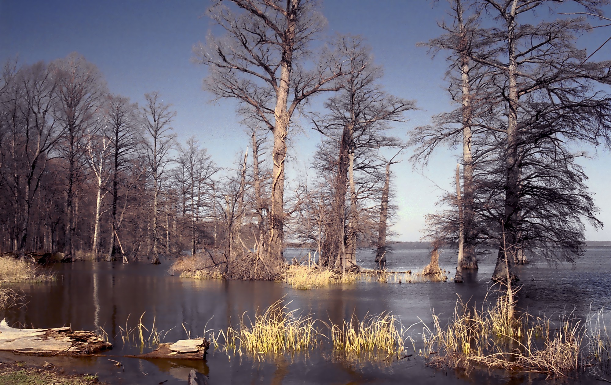 | 2,000 × 1,260(810 KB) | JeremyA | improved |
| 20:12, 5 November 2006 |  | 2,000 × 1,260(1.32 MB) | JeremyA | new version | |
| 20:06, 19 March 2006 | | 2,002 × 1,255(1.89 MB) | JeremyA | Reelfoot Lake, Tennessee. © Jeremy Atherton, 2003.Category:Lakes in the United StatesCategory:Tennessee |
O+O
No comments:
Post a Comment
Hi Everybody! Please say hello and follow so I know you are here! Due to the inconsideration of people trying to put commercials on my blog comment area, I have restricted use of anonymous posts. Sorry that some hurt all.
My public email is katescabin@gmail.com No spammers or trolls