

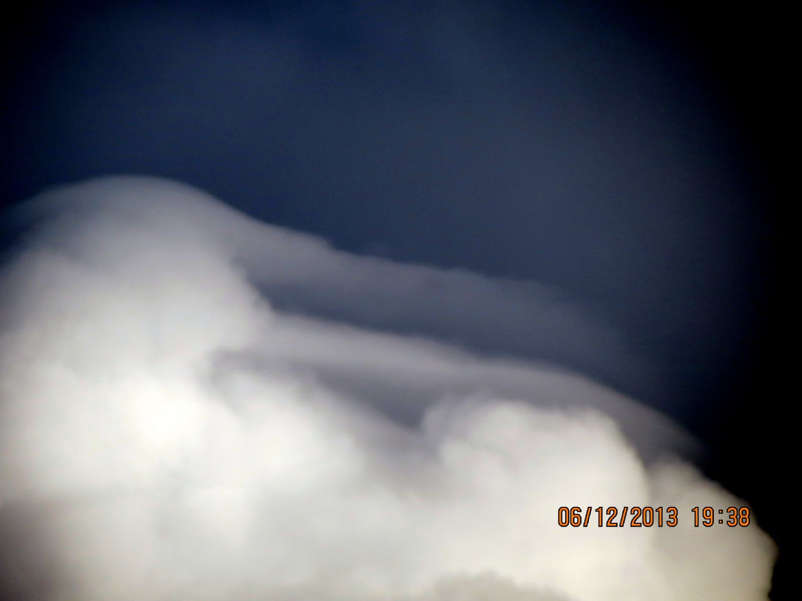
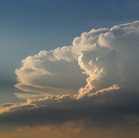
A "Block" usually refers to a city street and is limited in size. Out here in the country, the blocks can be pretty long! I can see for miles above the trees. I am so thrilled by the cloud activity this year after the past droughts and no clouds. Anyway, on this day, I witnessed the formation of the "perfect" rain storm cloud system at the end of my block. The clouds rose quickly like a big mountain above the trees. They were perfect formation to produce rain under that top. I did not get any rain here, but I was completely overwhelmed by the beauty of the system that developed before my eyes. It was magical, as if some new kid rode into town on a big red horse and just showed them how it is done! A real 'hotdogger' who just rode off into the sunset leaving a fine gentle rain in the dust! Your photostudy and slideshow are of the formation and life of this beautiful storm. Your infostudy is from Wikipedia and a new resource from the dept of Energy. Enjoy!


https://en.wikipedia.org/wiki/Storm
Storm
From Wikipedia, the free encyclopedia
A storm is any disturbed state of an astronomical body's atmosphere especially affecting its surface, and strongly implying severe weather. It may be marked by strong wind, hail, thunder and/orlightning (a thunderstorm), heavy precipitation (snowstorm, rainstorm), heavy freezing rain (ice storm), strong winds (tropical cyclone, windstorm), or wind transporting some substance through theatmosphere as in a dust storm, blizzard, sandstorm, etc. Storms generally lead to negative impacts to lives and property such as storm surge, heavy rain or snow (causing flooding or road impassibility), lightning, wildfires, and vertical wind shear; however, systems with significant rainfall can alleviate drought in places they move through. Heavy snowfall can allow special recreational activities to take place which would not be possible otherwise, such as skiing and snowmobiling.
Formation[edit]

Storms are created when a center of low pressure develops with a system of high pressure surrounding it. This combination of opposing forces can create winds and result in the formation of storm clouds, such as thecumulonimbus. Small localized areas of low pressure can form from hot air rising off hot ground; resulting in smaller disturbances such as dust devils and whirlwinds.
Types[edit]


There are many varieties and names for storms.
- Ice storm – Ice storms are one of the most dangerous forms of winter storms. When surface temperatures are below freezing, but a thick layer of above freezing air remains aloft above ground level, rain can fall into the freezing layer and freeze upon impact into a glaze which is known as Freezing Rain. In general, 8 millimetres (0.31 in) of accumulation is all that is required, especially in combination with breezy conditions, to start downing power lines as well as tree limbs.[2] Ice storms also make unheated road surfaces too slick to drive upon. Ice storms can vary in time range from hours to days and can cripple both small towns and large urban centers alike.
- Blizzard – There are varying definitions for blizzards, both over time and by location. In general, a blizzard is accompanied by gale-force winds, heavy snow (accumulating at a rate of at least 5 centimeters (2 in) per hour), and very cold conditions (below approximately -10 degrees Celsius or 14 F). As of late, the temperature criterion has fallen out of the definition across the United States[3]
- Snowstorm – A heavy fall of snow accumulating at a rate of more than 5 centimeters (2 in) per hour that lasts several hours. Snow storms, especially ones with a high liquid equivalent and breezy conditions, can down tree limbs, cut off power, and paralyze travel over a large region.
- Ocean Storm – Storm conditions out at sea are defined as having sustained winds of 48 knots (55 mph or 90 km/h) or greater.[4] Usually just referred to as a storm, these systems can sink vessels of all types and sizes.
- Firestorm – Firestorms are conflagrations which attain such intensity that they create and sustain their own wind systems. It is most commonly a natural phenomenon, created during some of the largest bushfires, forest fires, and wildfires. The Peshtigo Fire is one example of a firestorm. Firestorms can also be deliberate effects of targeted explosives such as occurred as a result of the aerial bombings of Dresden and Tokyo during World War II. Nuclear detonations almost invariably generate firestorms
- Dust devil – a small, localized updraft of rising air.
- Wind storm – A storm marked by high wind with little or no precipitation.[5] Windstorm damage often opens the door for massive amounts of water and debris to cause further damage to a structure.[6] European windstormsand derechos are two type of windstorms.[7]
- Squall – sudden onset of wind increase of at least 16 knots (30 km/h) or greater sustained for at least one minute.
- Gale – An extratropical storm with sustained winds between 34-48 knots (39-55 mph or 63–90 km/h).[4]
- Thunderstorm – A thunderstorm is a type of storm that generates lightning and the attendant thunder. It is normally accompanied by heavy precipitation. Thunderstorms occur throughout the world, with the highest frequency in tropical rainforest regions where there are conditions of high humidity and temperature along with atmospheric instability. These storms occur when high levels of condensation form in a volume of unstable air that generates deep, rapid, upward motion in the atmosphere. The heat energy creates powerful rising air currents that swirl upwards to the tropopause. Cool descending air currents produce strong downdraughts below the storm. After the storm has spent its energy, the rising currents die away and downdraughts break up the cloud. Individual storm clouds can measure 2–10 km across.
- Tropical cyclone – A tropical cyclone is a storm system with a closed circulation around a centre of low pressure, fueled by the heat released when moist air rises and condenses. The name underscores its origin in the tropics and their cyclonic nature. Tropical cyclones are distinguished from other cyclonic storms such as nor'easters and polar lows by the heat mechanism that fuels them, which makes them "warm core" storm systems.
- Tropical cyclones form in the oceans if the conditions in the area are favorable, and depending on their strength and location, there are various terms by which they are called, such as tropical depression, tropical storm, hurricane and typhoon.[8]
- Hailstorm – a type of storm that precipitates round chunks of ice. Hailstorms usually occur during regular thunder storms. While most of the hail that precipitates from the clouds is fairly small and virtually harmless, there are occasional occurrences of hail greater than 2 inches in diameter that can cause much damage and injuries.
- Tornado – A tornado is a violent, destructive wind storm occurring on land. Usually its appearance is that of a dark, funnel-shaped cyclone. Often tornadoes are preceded by a thunderstorm and a wall cloud. They are often called the most destructive of storms, and while they form all over the world, the interior of the United States is the most prone area, especially throughout Tornado Alley.
SAVE THE LINK FOR THIS NEW RESOURCE I FOUND FOR US:
From U.S. Dept of Energy
See Link for complete Article
http://www.pnl.gov/science/highlights/highlight.asp?id=1318
Skip to Main ContentU.S. Department of Energ
Atmospheric Sciences & Global Change Division
Research Highlights
February 2013
The Short and the Long of Storms
Tracing a storm's life with a trifecta of data
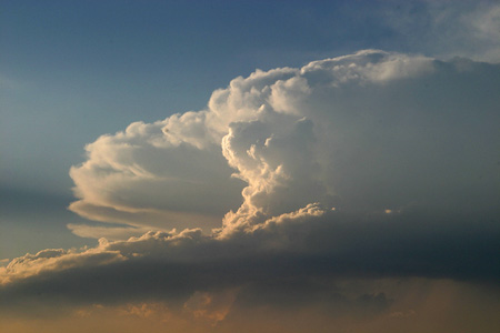
Deep storm cloud systems typically include three cloud partners: intense centers with strong vertical winds and heavy rain, spread-out areas of lower “flat” clouds that produce light to moderate rain, and a distinctive anvil shaped cloud, not associated with rain but a clear marker of a large storm system. Photo courtesy of the National Oceanic and Atmospheric Administration and the Department of Commerce. Enlarge Image
Results: The genesis of a thunderstorm determines its duration. Scientists at Pacific Northwest National Laboratory found that the lifetime of large storm systems lasting less than six hours can be traced to the intensity of the storm's initial onset. In storms lasting longer than six hours, they found the storm magnifies when the relative humidity is up to 50 percent higher and, as the storm deepens, has a 40 percent change in the difference between the winds at the top and bottom of the storm. These two conditions feed a continuous growth of the system's rain area which prolongs the storm lifetime.
Why It Matters: Every storm is as unique as a fingerprint. Like fingerprints, storms leave clues to their beginnings that scientists are using to paint a complete picture within climate models. The regions of the world encompassing most of the United States, Europe and much of Asia are subject to fast-changing weather systems prompted by air moving in from both the tropics and the poles. Extreme weather such as thunderstorms, hurricanes and cyclones are a yearly occurrence and affect millions of people worldwide. Scientists are working on a better fundamental understanding of the processes that create and fortify strong storm systems. With information gathered from direct observations combined with improved cloud simulations, scientists can help provide the long-term information needed to predict future storms under the influences of climate change.
Methods: The research team used observational data from geostationary satellites, ground-based precipitation radars and a regional reanalysis in the United States to analyze deep convective systems in the mid-latitudes. The study implemented an automated satellite tracking algorithm to follow the initiation, maturity and decay of individual storm systems. The team also used a new hybrid classification algorithm that classifies the three parts of the storm system (convective core, stratiform rain and anvil clouds) to combine analysis of satellite and radar data. The team found that factors most important to produce anvil clouds are the size and strength of the convective updraft, stratiform rain area and ambient upper tropospheric wind speed and wind shear. Collocating the reanalysis data with the tracked convective systems, the team used 4,221 tracked convective systems of two warm seasons during May through August, in both 2010 to 2011 to study the desired environment.
By showing the importance of mesoscale organization and ambient environment for deep convective system evolution, their findings provide long-term statistics to compare with models of all scales and evaluate their performance in simulating deep convection.
What's Next? The authors of the study will focus on understanding the impact of all types of large-scale environmental conditions to convective systems that occur within a typical global climate grid area.
Acknowledgments:
Sponsors: This research was funded by the National Oceanographic and Atmospheric Administration. The PNNL authors were supported by the U.S. Department of Energy (DOE) Office of Science Atmospheric System Research (ASR) program. The University of North Dakota authors were also supported by the ASR program, the NASA Clouds and the Earth's Radiant Energy System (CERES) project, and the NASA Experimental Program to Stimulate Competitive Research (EPSCoR). The NASA Langley authors were supported by both the CERES and ASRprograms.
Research Team: Zhe Feng and Sally McFarlane from PNNL; Xiquan Dong, Baike Xi and Aaron Kennedy from University of North Dakota; and Bing Lin and Patrick Minnis from NASA Langley Research Center.
Research Area: Climate & Earth Systems Science
Reference: Feng Z, X Dong, B Xi, SA McFarlane, A Kennedy, B Lin, and P Minnis. 2013. "Life Cycle of Midlatitude Deep Convective Systems in a Lagrangian Framework." Journal of Geophysical Research-Atmospheres 117(D23201). DOI:10.1029/2012JD018362.


https://www.google.com/search?q=hot+dogger&newwindow=1&tbm=isch&tbo=u&source=univ&sa=X&ei=aYG8UeqqDo_U8wSQnIG4Ag&ved=0CJoBELAE&biw=1151&bih=627
o+o
No comments:
Post a Comment
Hi Everybody! Please say hello and follow so I know you are here! Due to the inconsideration of people trying to put commercials on my blog comment area, I have restricted use of anonymous posts. Sorry that some hurt all.
My public email is katescabin@gmail.com No spammers or trolls