
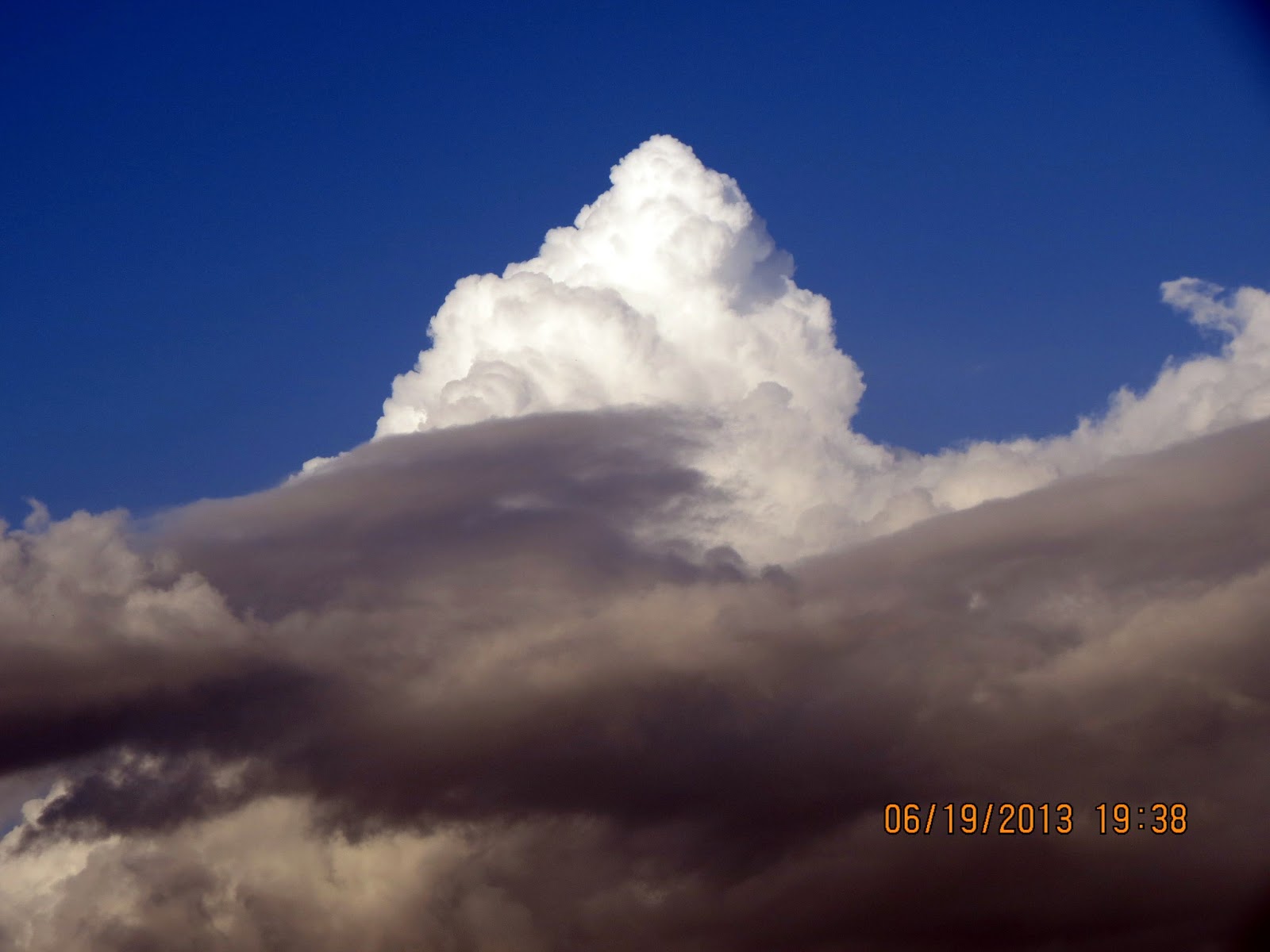
What do You see in this first image? Do You see a white mountain against a blue sky? Only one problem: we do not have white mountains in South Texas! So when I see something like this through the top of the trees as I am walking down the road, it can only mean one thing: that is one huge boiling cloud top on top of a giant cloud system. Let me introduce you to the Cumulonimbus Cloud in your infostudy. Then, we will ride out to the road where we can see this complete cloud system!
Come on in and put your head in the clouds!

http://en.wikipedia.org/wiki/Cumulonimbus_cloud
Cumulonimbus cloud
From Wikipedia, the free encyclopedia
| Cumulonimbus clouds | |
|---|---|
 Cumulonimbus capillatus incus | |
| Abbreviation | Cb |
| Symbol | |
| Genus | Cumulonimbus (heap, cloud/severe rain) |
| Altitude | 2,000–16,000 m (6,500–60,000 ft) |
| Classification | Family D (Vertically developed) |
| Appearance | Very tall and large clouds |
| Precipitation cloud? | Yes, often intense, but may be virga (virga—occasionally a streak of precipitation but evaporates before it hits the ground) |
Appearance[edit]


Cumulonimbus clouds typically are accompanied by lower altitude cumulus clouds, growing vertically instead of horizontally, contributing to the mushroom shape of the cumulonimbus. The cumulonimbus base may extend several miles across and occupy low to middle altitudes- formed at altitude from approximately 500 to 13,000 feet (150 to 3,960 meters). Peaks typically reach to as much as 20,000 feet (6,090 meters), with extreme instances as high as 75,000 feet (23,000 meters).[1] Well-developed cumulonimbus clouds are characterised by a flat, anvil-like top (anvil dome), caused by wind shear or inversion near the tropopause. The shelf of the anvil may precede the main cloud's vertical component for many miles, and be accompanied by lightning. Occasionally, rising air parcels surpass the equilibrium level (due to momentum) and form an overshooting top culminating at themaximum parcel level. When vertically developed, this largest of all clouds usually extends through all three cloud regions. Even the smallest cumulonimbus cloud dwarfs its neighbours in comparison.
Effects[edit]
See also: Severe weather and Thunderstorm
Cumulonimbus storm cells can produce torrential rain of a convective nature and flash flooding, as well as straight-line winds. Most storm cells die after about 20 minutes, when the precipitationcauses more downdraft than updraft, causing the energy to dissipate. If there is enough solar energyin the atmosphere, however (on a hot summer's day, for example), the moisture from one storm cell can evaporate rapidly—resulting in a new cell forming just a few miles from the former one. This can cause thunderstorms to last for several hours. Cumulonimbus clouds can also bring dangerous winter storms (called "blizzards") which bring lightning, thunder, and torrential snow.
Cloud types[edit]
Main article: List of cloud types
Clouds form when the dewpoint of water is reached in the presence of condensation nuclei in the troposphere. The atmosphere is a dynamic system, and the local conditions of turbulence, uplift and other parameters give rise to many types of clouds. Various types of clouds occur frequently enough to have been categorized. Furthermore, some atmospheric processes can make the clouds organize in distinct patterns such as wave clouds or actinoform clouds. These are large-scale structures and are not always readily identifiable from single point of view.


Part 2- Short slideshow of explosive break up of the Cloud System (drove out 5 minutes to side road).
http://en.wikipedia.org/wiki/Atmospheric_thermodynamics
Atmospheric thermodynamics
From Wikipedia, the free encyclopedia
Atmospheric thermodynamics is the study of heat to work transformations (and the reverse) in the earth’s atmospheric system in relation to weather or climate. Following the fundamental laws of classical thermodynamics, atmospheric thermodynamics studies such phenomena as properties of moist air, formation of clouds, atmospheric convection, boundary layer meteorology, and vertical stabilities in the atmosphere. Atmospheric thermodynamic diagramsare used as tools in the forecasting of storm development. Atmospheric thermodynamics forms a basis for cloud microphysics and convectionparameterizations in numerical weather models, and is used in many climate considerations, including convective-equilibrium climate models.
Overview[edit]
Atmospheric thermodynamics focuses on water and its transformations. Areas of study include the law of energy conservation, the ideal gas law, specific heat capacities, adiabatic processes (in which entropy is conserved), and moist adiabatic processes. Most of tropospheric gases are treated as ideal gases and water vapor is considered as one of the most important trace components of air.
Advanced topics are phase transitions of water, homogeneous and inhomogeneous nucleation, effect of dissolved substances on cloud condensation, role of supersaturation on formation of ice crystals and cloud droplets. Considerations of moist air and cloud theories typically involve various temperatures, such as equivalent potential temperature, wet-bulb and virtual temperatures. Connected areas are energy, momentum, and mass transfer, turbulence interaction between air particles in clouds, convection, dynamics of tropical cyclones, and large scale dynamics of the atmosphere.
The major role of atmospheric thermodynamics is expressed in terms of adiabatic and diabatic forces acting on air parcels included in primitive equations of air motion either as grid resolved or subgrid parameterizations. These equations form a basis for the numerical weather and climate predictions.
History[edit]
In the early 19th century thermodynamicists such as Sadi Carnot, Rudolf Clausius, and Emile Clapeyron developed mathematical models on the dynamics of bodies fluids and vapors related to the combustion and pressure cycles of atmospheric steam engines; one example is the Clausius-Clapeyron equation. In 1873, thermodynamicist Josiah Willard Gibbs published "Graphical Methods in the Thermodynamics of Fluids."

These sorts of foundations naturally began to be applied towards the development of theoretical models of atmospheric thermodynamics which drew the attention of the best minds. Papers on atmospheric thermodynamics appeared in the 1860s that treated such topics as dry and moist adiabatic processes. In 1884 Heinrich Hertzdevised first atmospheric thermodynamic diagram (emagram).[1] Pseudo-adiabatic process was coined by von Bezold describing air as it is lifted, expands, cools, and eventually precipitates its water vapor; in 1888 he published voluminous work entitled "On the thermodynamics of the atmosphere".[2]
In 1911 von Alfred Wegener published a book "Thermodynamik der Atmosphäre", Leipzig, J. A. Barth. From here the development of atmospheric thermodynamics as a branch of science began to take root. The term "atmospheric thermodynamics", itself, can be traced to Frank W. Verys 1919 publication: “The radiant properties of the earth from the standpoint of atmospheric thermodynamics” (Occasional scientific papers of the Westwood Astrophysical Observatory). By the late 1970s various textbooks on the subject began to appear. Today, atmospheric thermodynamics is an integral part of weather forecasting.
Chronology[edit]
- 1751 Charles Le Roy recognized dew point temperature as point of saturation of air
- 1782 Jacques Charles made hydrogen balloon flight measuring temperature and pressure in Paris
- 1784 Concept of variation of temperature with height was suggested
- 1801-1803 John Dalton developed his laws of pressures of vapours
- 1804 Joseph Louis Gay-Lussac made balloon ascent to study weather
- 1805 Pierre Simon Laplace developed his law of pressure variation with height
- 1841 James Pollard Espy publishes paper on convection theory of cyclone energy
- 1889 Herman von Helmholtz and John William von Bezold used the concept of potential temperature, von Bezold used adiabatic lapse rate and pseudoadiabat
- 1893 Richard Asman constructs first aerological sonde (pressure-temperature-humidity)
- 1894 John Wilhelm von Bezold used concept of equivalent temperature
- 1926 Sir Napier Shaw introduced tephigram
- 1933 Tor Bergeron published paper on "Physics of Clouds and Precipitation" describing precipitation from supercooled (due to condensational growth of ice crystals in presence of water drops)
- 1946 Vincent J. Schaeffer and Irving Langmuir performed the first cloud-seeding experiment
- 1986 K. Emanuel conceptualizes tropical cyclone as Carnot heat engine
Tropical cyclone Carnot cycle[edit]

The thermodynamic structure of the hurricane can be modelled as a heat engine [3] running between sea temperature of about 300K and tropopause which has temperature of about 200K. Parcels of air traveling close to the surface take up moisture and warm, ascending air expands and cools releasing moisture (rain) during the condensation. The release of latent heat energy during the condensation provides mechanical energy for the hurricane. Both a decreasing temperature in the upper troposphere or an increasing temperature of the atmosphere close to the surface will increase the maximum winds observed in hurricanes. When applied to hurricane dynamics it defines a Carnot heat engine cycle and predicts maximum hurricane intensity.
Water vapor and global climate change[edit]
Main articles: Clausius-Clapeyron relation and August-Roche-Magnus approximation
The Clausius-Clapeyron relation shows how the water-holding capacity of the atmosphere increases by about 8% per Celsius increase in temperature. (It does not directly depend on other parameters like the pressure or density.) This water-holding capacity, or "equilibrium vapor pressure," can be approximated using the August-Roche-Magnus formula
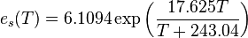
(where  is the equilibrium or saturation vapor pressure in hPa, and
  is temperature in degrees Celsius). This shows that when atmospheric temperature increases (e.g., due to greenhouse gases) the absolute humidity should also increase exponentially (assuming a constant relative humidity). However, this purely thermodynamic argument is subject of considerable debate because convective processes might cause extensive drying due to increased areas of subsidence, efficiency of precipitation could be influenced by the intensity of convection, and because cloud formation is related to relative humidity
is the equilibrium or saturation vapor pressure in hPa, and is temperature in degrees Celsius). This shows that when atmospheric temperature increases (e.g., due to greenhouse gases) the absolute humidity should also increase exponentially (assuming a constant relative humidity). However, this purely thermodynamic argument is subject of considerable debate because convective processes might cause extensive drying due to increased areas of subsidence, efficiency of precipitation could be influenced by the intensity of convection, and because cloud formation is related to relative humidityPart 3- The return home as a huge new cloud tower rises from the ashes of the last one!

Back home from the storm cloud chasing adventure. The cloud followed me!! (But NO RAIN for me)


O+O
No comments:
Post a Comment
Hi Everybody! Please say hello and follow so I know you are here! Due to the inconsideration of people trying to put commercials on my blog comment area, I have restricted use of anonymous posts. Sorry that some hurt all.
My public email is katescabin@gmail.com No spammers or trolls