
Hi Everybody!!
We are so lucky to have all these great videos from You Tube and Images/Information from Wikipedia right at our fingertips. We can have all the ICE we want in the middle of Summer! Tonight we are going to GREENLAND. We will find out for ourself what this melting Ice looks like. It really does not matter whether You believe in Global Warming or Not. There is nothing anybody can do at this point in time that would result in reversal of Global Warming Effects. (my opinion) No one out of 7 billion people will ever agree on anything on a Global Scale in time to come together as the human species for the sake of the human species and the Earth.
Plan B: Make preparations to live on Warmer Earth!
(Move away from the coasts, for example). Build different buildings to protect from heat and sun. Many things you can do or nothing at all. I have gathered several videos showing the different things going on in Greenland. I found them all very interesting. I hope You will enjoy them also! I do not Thank Everybody enough for visiting the Blog, but I really do appreciate so many people coming from all the different countries. It just feels more like a World Adventure when You are traveling with me on these trips we are taking to see all we can see for free!
Enjoy the Big Chill or the Big Thaw, however You want to look at it!
To me it looks very cold!!!!!!!!!!!

http://en.wikipedia.org/wiki/Greenland
Greenland
From Wikipedia, the free encyclopedia
| Greenland
Kalaallit Nunaat
| ||||||
|---|---|---|---|---|---|---|
| ||||||
| Anthem: Nunarput utoqqarsuanngoravit(Greenlandic) | ||||||
.svg) | ||||||
| Capital (and largest city) | Nuuk (Godthåb) 64°10′N 51°44′W | |||||
| Official language(s) | Greenlandic(Kalaallisut)[a] | |||||
| Other language(s) | Danish | |||||
| Ethnic groups | 88% Inuit (including Inuit-Danish mixed) 12% Europeans (mostly Danes) | |||||
| Demonym | Greenlander, Greenlandic | |||||
| Government | Parliamentary democracy within aconstitutional monarchy | |||||
| - | Queen | Margrethe II | ||||
| - | High Commissioner | Mikaela Engell | ||||
| - | Prime Minister | Kuupik Kleist | ||||
| Legislature | Landsting / Inatsisartut | |||||
| Autonomy | within the Kingdom of Denmark | |||||
| - | Norwegian sovereignty[b] | 1261 | ||||
| - | Contact re-established | 1721 | ||||
| - | Ceded to Denmark[b] | 14 January 1814 | ||||
| - | Status of amt | 5 June 1953 | ||||
| - | Home rule | 1 May 1979 | ||||
| - | Further autonomy and self rule | 21 June 2009[1][2] | ||||
| Area | ||||||
| - | Total | 2,166,086 km2 (12th) 836,109 sq mi | ||||
| - | Water (%) | 83.1[d] | ||||
| Population | ||||||
| - | January 2011 estimate | 56,615[3] | ||||
| - | Density | 0.027/km2 (241st) 0.069/sq mi | ||||
| GDP (PPP) | 2007 estimate | |||||
| - | Total | $2.122 billion (n/a) | ||||
| - | Per capita | $37,517[e] (n/a) | ||||
| HDI (1998) | 0.927[4] (very high) (n/a) | |||||
| Currency | Danish krone (DKK) | |||||
| Time zone | (UTC+0 to −4) | |||||
| Drives on the | right | |||||
| ISO 3166 code | GL | |||||
| Internet TLD | .gl | |||||
| Calling code | +299 | |||||
| a.^ Greenlandic (Kalaallisut) has been the sole official language of Greenland since 2009.[1][5] b. ^ Danish monarchy reached Greenland in 1380 with the reign of Olav IV in Norway. b. ^ Greenland, the Faeroes and Iceland were formally Norwegian possessions until 1814 despite 400 years of Danish monarchy beforehand. c. ^ As of 2000: 410,449 km2 (158,475 sq mi) ice-free; 1,755,637 km2 (677,855 sq mi) ice-covered. Density: 0.14/km2 (0.36 /sq. mi) for ice-free areas. d. ^ 2001 estimate. | ||||||


Greenland (Kalaallisut: Kalaallit Nunaat, "Land of the Kalaallit";[6] Danish: Grønland) is anautonomous country within the Kingdom of Denmark, located between the Arctic andAtlantic Oceans, east of the Canadian Arctic Archipelago. Though physiographically a part of the continent of North America, Greenland has been politically and culturally associated with Europe (specifically Norway and later Denmark) for more than a millennium. Greenland is, by area, the world's largest island.[7] With a population of 56,615 (January 2011 estimate) it is the least densely populated dependency or country in the world.[8]
Greenland has been inhabited, though not continuously, by Arctic peoples via Canada for 4,500–5,000 years.[9][10] In the 10th century, Norsemen settled on the uninhabited southern part of Greenland. In the 13th century, the Inuit arrived, and in the late 15th century the Norse colonies disappeared. In the early 18th century, contact betweenScandinavia and Greenland was re-established and Denmark established rule over Greenland.
Greenland became a Danish colony in 1814 after being under the rule of Denmark-Norwayfor centuries. With the Constitution of Denmark of 1953, Greenland became a part of theDanish Realm in a relationship known in Danish as Rigsfællesskabet (Commonwealth of the Realm). In 1979 Denmark granted home rule to Greenland, and in 2008 Greenlandvoted to transfer more power from the Danish royal government to the local Greenlandicgovernment. This became effective the following year, with the Danish royal government in charge of foreign affairs, security (defence-police-justice), and financial policy, and providing a subsidy of DKK 3.4 billion. This subsidy will be gradually diminishing over time as Greenland's own economy is expected to become stronger due to income from resource extraction.
Geography and climate
Main article: Geography of Greenland
See also: Administrative divisions of Greenland, Territorial claims in the Arctic, Climate change in the Arctic, and Climate of the Arctic#Greenland

Greenland lies between latitudes 60° and 84°N, and longitudes 11° and 74°W and is the third largest country in North America.[37] The Atlantic Ocean borders Greenland's southeast; the Greenland Seais to the east; the Arctic Ocean is to the north; and Baffin Bay is to the west. The nearest countries are Canada, to the west across Baffin Bay, and Iceland, east of Greenland in the Atlantic Ocean. Greenland also contains the world's largest national park, and is the world's largest island and thelargest dependent territory by area in the world.
The average[clarification needed] annual temperatures of Nuuk, Greenland vary from -9 to 7 °C (16 to 45 °F)

The total area of Greenland is 2,166,086 km2 (836,330 sq mi) (including other offshore minor islands), of which theGreenland ice sheet covers 1,755,637 km2 (677,855 sq mi) (81%) and has a volume of approximately 2,850,000 km3(680,000 cu mi).[38] The highest point on Greenland isGunnbjørn Fjeld at 3,700 m (12,139 ft). The majority of Greenland, however, is less than 1,500 m (4,921 ft) in elevation.
The weight of the ice sheet has depressed the central land area to form a basin lying more than 300 m (984 ft) below sea level,[39][40] while elevations rise suddenly and steeply near the coast.[41] The ice flows generally to the coast from the center of the island. A survey led by French scientist Paul-Emile Victor in 1951 concluded that, under the ice sheet, Greenland was composed of three large islands.[42]
All towns and settlements of Greenland are situated along the ice-free coast, with the population being concentrated along the west coast. The northeastern part of Greenland is not part of any municipality, but is the site of the world's largest national park, Northeast Greenland National Park.

At least four scientific expedition stations and camps had been established on the ice sheet in the ice-covered central part of Greenland (indicated as pale blue in the map to the right): Eismitte, North Ice, North GRIP Camp and The Raven Skiway. Currently, there is a year-round station, Summit Camp, on the ice sheet, established in 1989. The radio station Jørgen Brønlund Fjord was, until 1950, the northernmost permanent outpost in the world.

The extreme north of Greenland, Peary Land, is not covered by an ice sheet, because the air there is too dry to produce snow, which is essential in the production and maintenance of an ice sheet. If the Greenland ice sheet were to melt away completely, the world's sea level would rise by more than 7 m (23 ft).[43]

Between 1989 and 1993, U.S. and European climateresearchers drilled into the summit of Greenland's ice sheet, obtaining a pair of 3 km (1.9 mi) long ice cores. Analysis of the layering and chemical composition of the cores has provided a revolutionary new record of climate change in the Northern Hemisphere going back about 100,000 years, and illustrated that the world's weather and temperature have often shifted rapidly from one seemingly stable state to another, with worldwide consequences.[44] The glaciers of Greenland are also contributing to a rise in the global sea level at a faster rate than was previously believed.[45]Between 1991 and 2004, monitoring of the weather at one location (Swiss Camp) showed that the average winter temperature had risen almost 6 °C (11 °F).[46] Other research has shown that higher snowfalls from the North Atlantic oscillation caused the interior of the ice cap to thicken by an average of 6 cm or 2.36 in/yr between 1994 and 2005.[47]
However, a recent study suggests a much warmer planet in relatively recent geological times:
Scientists who probed 2 km (1.2 mi) through a Greenland glacier to recover the oldest plant DNA on record said that the planet was far warmer hundreds of thousands of years ago than is generally believed.DNA of trees, plants and insects including butterflies and spiders from beneath the southern Greenland glacier was estimated to date to 450,000 to 900,000 years ago, according to the remnants retrieved from this long-vanished boreal forest. That view contrasts sharply with the prevailing one that a lush forest of this kind could not have existed in Greenland any later than 2.4 million years ago. These DNA samples suggest that the temperature probably reached 10 °C (50 °F) in the summer and −17 °C (1.4 °F) in the winter. They also indicate that during the last interglacial period, 130,000–116,000 years ago, when temperatures were on average 5 °C (9 °F) higher than now, the glaciers on Greenland did not completely melt away.[48]

In 1996, the American Top of the World expedition found the world's northernmost island off Greenland: ATOW1996. An even more northerly candidate was spotted during the return from the expedition, but its status is yet to be confirmed.
In 2007, the existence of a new island was announced. Named "Uunartoq Qeqertaq" (English:Warming Island), this island has always been present off the coast of Greenland, but was covered by a glacier. This glacier was discovered in 2002 to be shrinking rapidly, and by 2007 had completely melted away, leaving the exposed island.[49] The island was named Place of the Year by the Oxford Atlas of the World in 2007.[50] Ben Keene, the atlas's editor, commented: "In the last two or three decades, global warming has reduced the size of glaciers throughout the Arctic and earlier this year, news sources confirmed what climate scientists already knew: water, not rock, lay beneath this ice bridge on the east coast of Greenland. More islets are likely to appear as the sheet of frozen water covering the world's largest island continues to melt".
Some controversy surrounds the history of the island, specifically over whether the island might have been revealed during a brief warm period in Greenland during the mid-20th century
+++++++++++++++++++++++
FEATURE PRESENTATION:
VIDEO LINEUP OF GREENLAND
+++++++++++++++++++++++
Just Push Play
Just Push Play
Just Push Play
Just Push Play
Just Push Play
The Greenland Glacier Expedition: July 7–July 24, 2008
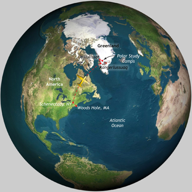
Greenland—the world’s largest island—is also home to one of the world’s largest ice sheets (after Antarctica). If Greenland’s two-mile-thick ice sheet melts completely, it would ultimately raise global sea level by 23 feet (7 meters), drowning significant portions of coastal regions under water. It would also add large quantities of fresh water to the ocean, with the potential to change ocean circulation patterns that could, in turn, affect rainfall patterns, fisheries, and climate.
This July, a team of four scientists from the Woods Hole Oceanographic
Institution and the University of Washington will return for their third year
to learn how Greenland’s ice sheet is disappearing. They are investigating glacial lakes, which form atop the ice sheet each spring and summer as returning sunlight melts ice and snow. They have found that as lake grow larger, large cracks can open up at their bases, allowing the lake water to drain in a dramatic surge all the way the bedrock at the bottom of glaciers. The water lubricates the base of the glacier, like grease on a railroad track, allowing glaciers to flow faster toward the coast and discharge more ice to the ocean.
As global temperatures rise, more lakes and cracks may form, accelerating the flow of ice to the sea.
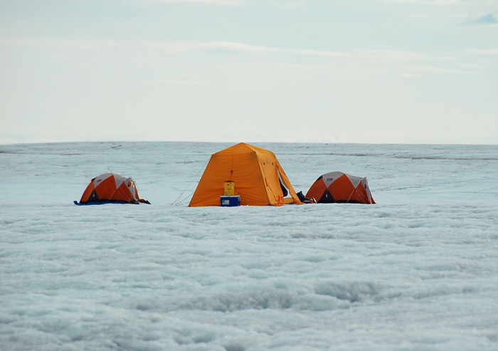
We'll be camping on the western edge of Greenland's ice sheet. (Photo by Mark Behn, WHOI)
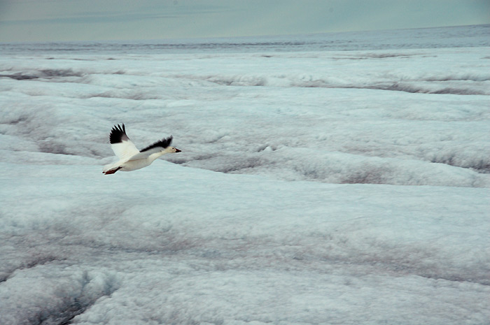
A snowgoose flies by—a rare sighting of wildlife where we'll be in Greenland. (Photo by Mark Behn, WHOI)
Life on the ice
Our fourth Polar Discovery expedition will take place entirely on ice—and that includes eating and sleeping. Except for short hotel stays at the beginning and end of the trip, we will camp in individual tents directly on the ice sheet. Helicopters will fly in the team with its entire supply of food, clothing, and science provisions, return once midway through the trip to help move camp, and return again to collect the team at the end of the field work. For safety, we’ll check in daily with the National Science Foundation, and we’ll communicate with Polar Discovery readers via satellite phones and computers powered by solar energy. Other than that, it’s just us and a whole lot of water and ice.
What about wildlife?
Whales, musk ox, reindeer, seals, birds, and polar bears all call Greenland home but do not live on the southwestern corner of ice sheet where we will work and camp. Also, there are no penguins in Greenland (they live in the southern hemisphere). In year’s past, wildlife sightings at the Greenland camps included a single fly that likely flew in with a helicopter, and one snow goose.
This research was funded by the National Science Foundation, NASA, and WHOI.
http://en.wikipedia.org/wiki/Ice_calving
A mass of ice calves from the Perito Moreno Glacier
Ice calving
From Wikipedia, the free encyclopedia
Causes

It is useful to classify causes of calving into first, second, and third order processes.[8]First order processes are responsible for the overall rate of calving at the glacier scale. The first order cause of calving is longitudinal stretching, which controls the formation ofcrevasses. When crevasses penetrate the full thickness of the ice, calving will occur.[9]Longitudinal stretching is controlled by friction at the base and edges of the glacier, glacier geometry and water pressure at the bed. These factors, therefore, exert the primary control on calving rate.
Second and third order calving processes can be considered to be superimposed on the first order process above, and control the occurrence of individual calving events, rather than the overall rate. Melting at the waterline is an important second order calving process as it undercuts the subaerial ice, leading to collapse. Other second order processes include tidal and seismic events, buoyant forces and melt water wedging.
When calving occurs due to waterline melting, only the subaerial part of the glacier will calve, leaving a submerged 'foot'. Thus, a third order process is defined, whereby upward buoyant forces cause this ice foot to break off and emerge at the surface. This process is extremely dangerous, as it has been known to occur, without warning, up to 300m from the glacier terminus.[10]
[edit]Calving law
Though many factors that contribute to calving have been identified, a reliable predictive mathematical formula is still under development. Data is currently being assembled from ice shelves in Antarctica and Greenland to help establish a 'calving law'. Variables used in models include properties of the ice such as thickness, density, temperature, c-axis fabric, impurity loading, though 'ice front normal spreading stress', is likely the most important variable, however it is usually not measured.[citation needed]
There are currently several concepts upon which to base a predictive law. One theory states that the calving rate is primarily a function of the ratio of tensile stress to vertical compressive stress, i.e., the calving rate is a function of the ratio of the largest to smallest principle stress. [11] Another theory, based on preliminary research, shows that the calving rate increases as a power of the spreading rate near the calving front.[citation needed]
[edit]Major calving events

[edit]Filchner-Ronne Ice Shelf
In October, 1988, the A-38 iceberg broke away from the Filchner-Ronne Ice Shelf. It was about 150 km x 50 km, a mass of ice bigger than the area of Delaware. A second calving occurred in May 2000 and created an iceberg 167 km x 32 km.
[edit]Amery Ice Shelf
A major calving event occurred in 1962 to 1963. Currently, there is a section at the front of the shelf referred to as the 'loose tooth'. This section, about 30 km by 30 km is moving at about 12 metres per day and is expected to eventually calve away.[12]
[edit]Ward Hunt Ice Shelf
The largest observed calving of an ice island happened at Ward Hunt Ice Shelf. Sometime between August 1961 and April 1962 almost 600 km2 of ice broke away.[13]
[edit]Ayles Ice Shelf
In 2005, nearly the entire shelf calved from the northern edge of Ellesmere Island. Since 1900, about 90% of Ellesmere Island's ice shelves have calved and floated away. This event was the biggest of its kind for at least the past 25 years. A total of 87.1 km2(33.6 sq mi) of ice was lost in this event. The largest piece was 66.4 km2 (25.6 sq mi) in area, (equivalent in area to approximately 11,000 football fields or slightly larger than the City of Manhattan.[14]
[edit]Larsen Ice Shelf
This large ice shelf, located in the Weddell Sea, extending along the east coast of Antarctic Peninsula, consists of three segments, two of which have calved. The Larsen B Ice Shelf calved and disintegrated in February 2002. Then in January 1995, the Larsen A Ice Shelf containing 3,250 km² of ice 220 m thick calved and disintegrated.
[edit]Jakobshavn Isbrae Glacier
Also known as the Jakobshavn Glacier or Sermeq Kujalleq, in an ongoing event, 35 billion tonnes of icebergs calve off and pass out of the fjord every year.
Just Push Play
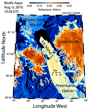
Satellite image from Aug. 5, 2010, shows the huge ice island calved from Greenland's Petermann Glacier. Courtesy of Prof. Andreas Muenchow, University of Delaware
Greenland glacier calves island 4 times the size of Manhattan, UD scientist reports
1:40 p.m., Aug. 6, 2010----A University of Delaware researcher reports that an “ice island” four times the size of Manhattan has calved from Greenland's Petermann Glacier. The last time the Arctic lost such a large chunk of ice was in 1962.
“In the early morning hours of August 5, 2010, an ice island four times the size of Manhattan was born in northern Greenland,” said Andreas Muenchow, associate professor of physical ocean science and engineering at the University of Delaware's College of Earth, Ocean, and Environment. Muenchow's research in Nares Strait, between Greenland and Canada, is supported by the National Science Foundation (NSF).
Satellite imagery of this remote area at 81 degrees N latitude and 61 degrees W longitude, about 620 miles [1,000 km] south of the North Pole, reveals that Petermann Glacier lost about one-quarter of its 43-mile long [70 km] floating ice-shelf.
Trudy Wohlleben of the Canadian Ice Service discovered the ice island within hours after NASA's MODIS-Aqua satellite took the data on Aug. 5, at 8:40 UTC (4:40 EDT), Muenchow said. These raw data were downloaded, processed, and analyzed at the University of Delaware in near real-time as part of Muenchow's NSF research.
Petermann Glacier, the parent of the new ice island, is one of the two largest remaining glaciers in Greenland that terminate in floating shelves. The glacier connects the great Greenland ice sheet directly with the ocean.
The new ice island has an area of at least 100 square miles and a thickness up to half the height of the Empire State Building.
“The freshwater stored in this ice island could keep the Delaware or Hudson rivers flowing for more than two years. It could also keep all U.S. public tap water flowing for 120 days,” Muenchow said.
The island will enter Nares Strait, a deep waterway between northern Greenland and Canada where, since 2003, a University of Delaware ocean and ice observing array has been maintained by Muenchow with collaborators in Oregon (Prof. Kelly Falkner), British Columbia (Prof. Humfrey Melling), and England (Prof. Helen Johnson).
“In Nares Strait, the ice island will encounter real islands that are all much smaller in size,” Muenchow said. “The newly born ice-island may become land-fast, block the channel, or it may break into smaller pieces as it is propelled south by the prevailing ocean currents. From there, it will likely follow along the coasts of Baffin Island and Labrador, to reach the Atlantic within the next two years.”
The last time such a massive ice island formed was in 1962 when Ward Hunt Ice Shelf calved a 230 square-mile island, smaller pieces of which became lodged between real islands inside Nares Strait. Petermann Glacier spawned smaller ice islands in 2001 (34 square miles) and 2008 (10 square miles). In 2005, the Ayles Ice Shelf disintegrated and became an ice island (34 square miles) about 60 miles to the west of Petermann Fjord.
Just Push Play
Just Push Play
...this is brendasue signing off from Rainbow Creek.
See You Next Time!
Love To All
Of Course,
One more Great Performance
A Flight Over Greenland
Just Push Play
I just found one more Great Video from my favorite Professor Stewart:
If you do not have time to watch right now, bookmark this page to return.
It is that Good-Just Push Play
O+O
Hallo brendasue !
ReplyDeleteEs ist wie immer sehr umfangreich , also komme ich wieder. Alles Gute für dich von Gisela aus Hamburg.
Hallo Gisela!
DeleteVielen Dank für Ihre anhaltende Liebe und Unterstützung. Es ist nicht notwendig, alles in der Blog zu sehen. Ich stellte weitere Informationen für diejenigen, die mehr wissen wollen! Ich bin froh, besuchen wir die Dinge auf die sozialen Medien zu ändern. Ich möchte nie mit Ihnen Kontakt aufnehmen zu verlieren! Grüße für ein gutes Wochenende in Hamburg!