

Hi Everybody:
This is a Special Report due to the Personal and Public Outrage regarding the murder of the Children. Evidence is showing several different stories. The dead suspect had handguns. The news video showed police opening a car trunk, discovering the long rifle and confirming it was the weapon used in the shootings. All of the victims were killed with rifle bullets, including the dead boy. I am left wondering: How did he shoot everybody and then himself, and then die, and then get up and go put the rifle in the trunk?
Some EVIL people are behind all this as You will see in the special vids. There is a plan being carried out in front of us, according to those investigating the murders. I am not asking You to believe one way or another. I am not asking You for anything. And, I have never asked for money. I just hope Your eyes open and You wake up and wake up the others.
See if You Can Help the IdahoPicker below.
http://www.youtube.com/watch?v=4Bjm3b7Ax2c
http://www.youtube.com/watch?v=l9l17GLHE6w
http://www.youtube.com/watch?v=47RY2O796dM
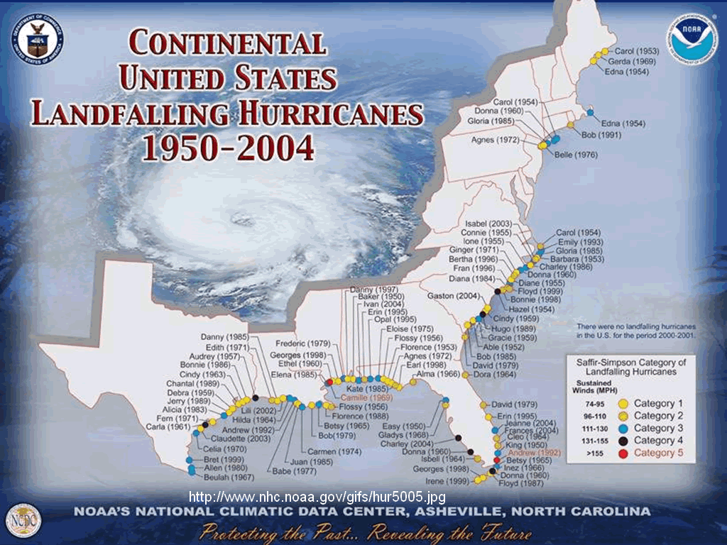
The Following Hurricane events have compromised these areas with floods already in the past.


Hurricane Katrina

http://www.wunderground.com/education/Katrinas_surge_contents.asp
Katrina's Storm Surge
A Weather Underground 16 part series about Hurricane Katrina, by Margie Kieper.
Hurricane Katrina of 2005 produced the highest storm surge ever recorded on the U.S. coast--an astonishing 27.8 feet at Pass Christian, Mississippi. This bested the previous U.S. record of 22.8 feet, which also occurred at Pass Christian, during 1969's Hurricane Camille. According to the NHC Katrina final report (PDF File), Hurricane Katrina brought a surge of 24 - 28 feet to a 20-mile stretch of Mississippi coast. Fully 90 miles of coast from eastern Louisiana to Alabama received a storm surge characteristic of a Category 3 hurricane. The colossal damage that resulted has been documented by blogger Margie Kieper during a series of blog posts that ran in the summer of 2006. The contents are reproduced here, and consist of an introduction explaining why the surge was so large, and 16 parts exploring the damage done to each stretch of the Gulf Coast ravaged by Hurricane Katrina in 2005.
Hurricane Katrina Storm Surge:
- Introduction
- Part 1: Grand Isle, Jefferson Parish, LA
- Part 2: Pilottown to Venice to Boothville, Plaquemines Parish, LA
- Part 3: Buras, Empire, Tropical Blend, Plaquemines Parish, LA
- Part 4: Pointe A La Hache, Belle Chasse, Plaquemines Parish, LA
- Part 5: St. Bernard Parish, LA
- Part 6: Eastern Orleans Parish, Rigolets, LA
- Part 7: Slidell, LA, and Pearlington, MS
- Part 8: Lakeshore to Waveland, MS
- Part 9: Lakeshore to Waveland, MS, continued
- Part 10: Bay St. Louis to Pass Christian, MS
- Part 11: Long Beach and Gulfport, MS
- Part 12: Biloxi and D’Iberville, MS
- Part 13: Porteaux Bay and Gulf Hills, MS
- Part 14: Ocean Springs to Gautier, Western Jackson County, MS
- Part 15: Pascagoula and Moss Point, Eastern Jackson County, MS
- Part 16: Bayou La Batre and Mobile, AL
http://www.fema.gov/sites/default/files/orig/fema_pdfs/pdf/hazard/flood/recoverydata/katrina/katrina_la_methods_v3.pdf
HURRICANE KATRINA SURGE INUNDATION AND
ADVISORY BASE FLOOD ELEVATION MAPS –
SUMMARY OF METHODS
Contract No. EMW-2000-CO-0247
Task Order No. 436 (Louisiana)
http://www.youtube.com/watch?v=s76Qn7bpCsQ
More Links: https://www.google.com/search?client=gmail&rls=gm&q=fema%20flood%20map%20hurricane%20katrina
The complete article is at the following link. Below is only a small excerpt.
http://www.nytimes.com/2012/11/13/nyregion/federal-flood-insurance-program-faces-new-stress.html?pagewanted=all&_r=0
Federal Flood Insurance Program Faces New Stress - NYTimes.com 
www.nytimes.com/.../federal-flood-insurance-program-faces-n...Share
Nov 12, 2012 – Graphic: How Hurricane Katrina Overwhelmed the Federal FloodInsurance Fund ... And despite some efforts in recent years, many of the flood mapsthe ... FEMA officials declined to address whether changes beyond the ...
The federal government’s flood insurance program, established in 1968, is one of the world’s largest. The insurance is mandatory for homeowners with a federally backed mortgage if they live in an area subject to flooding at least once every 100 years. The average annual flood insurance premium is about $615, but for homeowners in areas at higher risk of flooding, an annual policy can cost from $1,200 to $3,000, according to Steve Harty, president of National Flood Services, a claims-processing company, depending on the level of coverage.
The federal program collects about $3.5 billion in annual premiums. But in four of the past eight years, claims will have eclipsed premiums, most glaringly in 2005 — the year of Hurricanes Katrina, Rita and Wilma — when claims totaled $17.7 billion. Private insurance companies have long avoided offering flood insurance to homeowners.
“It’s like rat poison to them,” said Tony Bullock, an insurance industry lobbyist, explaining how the risk outweighs the benefit for private insurers. “You need the federal backstop.”
But the program is still a moneymaker for the private insurance industry. Even though these companies bear none of the risk, they take, on average, $1 billion a year of the premiums the government collects, as compensation for help in selling and servicing the policies. Federal auditors argue the payments are excessive.
Hurricane Ike


Hurricane Andrew
Hurricane Ivan
Hurricane Rita
http://en.wikipedia.org/wiki/List_of_ports_in_the_United_States
List of ports in the United States
From Wikipedia, the free encyclopedia
List
| Rank (by total trade) | Port name | Total trade | Foreign imports | Foreign exports | Foreign total | Domestic total |
|---|---|---|---|---|---|---|
| 1 | Port of South Louisiana | 224,187,320 | 40,087,413 | 64,683,390 | 104,770,803 | 119,416,519 |
| 2 | Port of Houston, Texas | 202,047,327 | 97,713,314 | 39,823,197 | 137,536,511 | 64,510,816 |
| 3 | Port of Beaumont, Texas | 91,697,948 | 65,315,960 | 5,558,256 | 70,874,216 | 20,823,732 |
| 4 | Port of Long Beach, California | 80,066,130 | 44,619,556 | 17,895,852 | 62,515,408 | 17,550,722 |
| 5 | Port of Corpus Christi, Texas | 78,924,757 | 44,989,804 | 8,805,253 | 53,795,057 | 25,129,700 |
| 6 | Port of New Orleans, Louisiana | 78,085,209 | 24,134,664 | 16,288,046 | 40,422,710 | 37,662,499 |
| 7 | Port of Huntington-Tristate, West Virginia | 77,307,514 | - | - | - | 77,307,514 |
| 8 | Port of Texas City, Texas | 68,282,902 | 46,384,689 | 4,421,097 | 50,805,786 | 17,477,116 |
| 9 | Port of Baton Rouge, Louisiana | 57,082,823 | 18,156,227 | 3,782,762 | 21,938,989 | 35,143,834 |
| 10 | Port of Mobile, Alabama | 56,211,796 | 19,916,120 | 9,401,885 | 29,318,005 | 26,893,791 |
| 11 | Port of Lake Charles, Louisiana | 54,768,322 | 27,036,374 | 4,656,604 | 31,692,978 | 23,075,344 |
| 12 | Plaquemines Parish, Louisiana | 54,404,720 | 9,307,882 | 8,386,407 | 17,694,289 | 36,710,431 |
| 13 | Port of Los Angeles, California | 51,931,730 | 32,420,155 | 11,451,697 | 43,871,852 | 8,059,878 |
| 14 | Hampton Roads, Virginia | 48,446,410 | 9,622,311 | 25,051,207 | 34,673,518 | 13,772,892 |
| 15 | Port of Tampa, Florida | 48,289,134 | 9,550,970 | 9,053,993 | 18,604,963 | 29,684,171 |
| 16 | Helen Delich Bentley Port of Baltimore,Maryland | 47,399,120 | 24,950,281 | 7,830,165 | 32,780,446 | 14,618,674 |
| 17 | Valdez, Alaska | 46,758,499 | 582 | 2,525 | 3,107 | 46,755,392 |
| 18 | Twin Ports of Duluth, Minnesota andSuperior, Wisconsin | 45,392,619 | 489,387 | 13,231,088 | 13,720,475 | 31,672,144 |
| 19 | Port of Pittsburgh, Pennsylvania | 41,034,808 | - | - | - | 41,034,808 |
| 20 | Port of Philadelphia, Pennsylvania | 35,219,613 | 21,123,144 | 314,263 | 21,437,407 | 13,782,206 |
| 21 | Pascagoula, Mississippi | 34,099,989 | 19,476,237 | 3,933,323 | 23,409,560 | 10,690,429 |
| 22 | Port of Freeport, Texas | 33,908,024 | 25,157,179 | 2,980,966 | 28,138,145 | 5,769,879 |
| See Link for the complete list- |
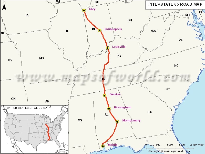
INTERSTATE 35

http://www.examiner.com/article/so-what-s-the-new-federal-highway-bill-anyway-nafta-superhighways
So what’s in the new federal highway bill anyway? NAFTA superhighways
Some have tried to convince the public that the Trans Texas Corridor and NAFTA Superhighways are dead. But Congress recently passed a new, two-year federal highway bill, Moving Ahead for Progress in the 21st Century (or MAP-21), that not only gives priority funding to these ‘high priority’ trade corridors, it also makes it easier to hand them over to private corporations using controversial public private partnership (P3) toll contracts.
On July 6, President Barack Obama signed MAP-21 into law. As with most bills these days, Congress had to pass it in order for us to know what’s in it. Only the committee members, conferees, and lobbyists had the access to know precisely what was in it, and big business, big energy, and various and sundry special interests got just what they wanted -- including state highway departments that got the environmental rules so relaxed, they can literally add toll lanes to any highway without so much as a public hearing or ANY study of the impacts, so long as it’s within the existing right of way.

Trans Texas Corridor resurrected, too?
Right before MAP-21 gained passage, TxDOT released a Request for Information (RFI) on June 22 regarding the SH 130 tollway, the only stretch of the Trans Texas Corridor TTC-35 to ever be built, seeking information from potential developers to build 'ancillary facilities' along SH 130 that could include gas stations, restaurants, hotels, and rest area development within the highway's right of way.
Right before MAP-21 gained passage, TxDOT released a Request for Information (RFI) on June 22 regarding the SH 130 tollway, the only stretch of the Trans Texas Corridor TTC-35 to ever be built, seeking information from potential developers to build 'ancillary facilities' along SH 130 that could include gas stations, restaurants, hotels, and rest area development within the highway's right of way.
It’s apparent TxDOT is getting into the land development business. This concept is identical to the Trans Texas Corridor. However, Section 228.053 of the Texas Transportation Code still gives the Department the authority to "contract with a person for the use of part of a toll project or system or lease part of a toll project or system for a gas station, garage, store, hotel, restaurant, railroad tracks, utilities, and telecommunications facilities and equipment and set the terms for the use or lease." Consider this to be on the chopping block when the 83rd legislature convenes in 2013.
Leasing out the public’s right of way is horrific abuse of eminent domain that creates a monopolistic cash cow for a single developer and the State of Texas. Why shouldn't the original landowners be afforded the opportunity to develop that land instead of the State? How can other facilities (gas stations, etc.) off the toll road be financially viable when there is a monopoly controlled by the state and a single developer actually located on the tollway itself?
How this began:
http://www.humanevents.com/2006/06/12/bush-administration-quietly-plans-nafta-super-highway/BUSH ADMINISTRATION QUIETLY PLANS NAFTA SUPER HIGHWAY
Quietly but systematically, the Bush Administration is advancing the plan to build a huge NAFTA SuperHighway, four football-fields-wide, through the heart of the U.S. along Interstate 35, from the Mexican border at Laredo, Tex., to the Canadian border north of Duluth, Minn.
As incredible as this plan may seem to some readers, the first Trans-Texas Corridor segment of the NAFTA Super Highway is ready to begin construction next year. Various U.S. government agencies, dozens of state agencies, and scores of private NGOs (non-governmental organizations) have been working behind the scenes to create the NAFTA Super Highway, despite the lack of comment on the plan by President Bush. The American public is largely asleep to this key piece of the coming “North American Union” that government planners in the new trilateral region of United States, Canada and Mexico are about to drive into reality.
Just examine the following websites to get a feel for the magnitude of NAFTA Super Highway planning that has been going on without any new congressional legislation directly authorizing the construction of the planned international corridor through the center of the country.
- NASCO, the North America SuperCorridor Coalition Inc., is a “non-profit organization dedicated to developing the world’s first international, integrated and secure, multi-modal transportation system along the International Mid-Continent Trade and Transportation Corridor to improve both the trade competitiveness and quality of life in North America.” Where does that sentence say anything about the USA? Still, NASCO has received $2.5 million in earmarks from the U.S. Department of Transportation to plan the NAFTA Super Highway as a 10-lane limited-access road (five lanes in each direction) plus passenger and freight rail lines running alongside pipelines laid for oil and natural gas. One glance at the map of the NAFTA Super Highway on the front page of the NASCO website will make clear that the design is to connect Mexico, Canada, and the U.S. into one transportation system.
- Kansas City SmartPort Inc. is an “investor based organization supported by the public and private sector” to create the key hub on the NAFTA Super Highway. At the Kansas City SmartPort, the containers from the Far East can be transferred to trucks going east and west, dramatically reducing the ground transportation time dropping the containers off in Los Angeles or Long Beach involves for most of the country. A brochure on the SmartPort website describes the plan in glowing terms: “For those who live in Kansas City, the idea of receiving containers nonstop from the Far East by way of Mexico may sound unlikely, but later this month that seemingly far-fetched notion will become a reality.”
- The U.S. government has housed within the Department of Commerce (DOC) an “SPP office” that is dedicated to organizing the many working groups laboring within the executive branches of the U.S., Mexico and Canada to create the regulatory reality for the Security and Prosperity Partnership. The SPP agreement was signed by Bush, President Vicente Fox, and then-Prime Minister Paul Martin in Waco, Tex., on March 23, 2005. According to the DOC website, a U.S.-Mexico Joint Working Committee on Transportation Planning hasfinalized a plan such that “(m)ethods for detecting bottlenecks on the U.S.-Mexico border will be developed and low cost/high impact projects identified in bottleneck studies will be constructed or implemented.” The report notes that new SENTRI travel lanes on the Mexican border will be constructed this year. The border at Laredo should be reduced to an electronic speed bump for the Mexican trucks containing goods from the Far East to enter the U.S. on their way to the Kansas City SmartPort.
- The Texas Department of Transportation (TxDOT) is overseeing the Trans-Texas Corridor(TTC) as the first leg of the NAFTA Super Highway. A 4,000-page environmental impact statement has already been completed and public hearings are scheduled for five weeks, beginning next month, in July 2006. The billions involved will be provided by a foreign company, Cintra Concessions de Infraestructuras de Transporte, S.A. of Spain. As a consequence, the TTC will be privately operated, leased to the Cintra consortium to be operated as a toll-road.
The details of the NAFTA Super Highway are hidden in plan view. Still, Bush has not given speeches to bring the NAFTA Super Highway plans to the full attention of the American public. Missing in the move toward creating a North American Union is the robust public debate that preceded the decision to form the European Union. All this may be for calculated political reasons on the part of the Bush Administration.
A good reason Bush does not want to secure the border with Mexico may be that the administration is trying to create express lanes for Mexican trucks to bring containers with cheap Far East goods into the heart of the U.S., all without the involvement of any U.S. union workers on the docks or in the trucks.
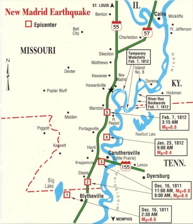

1811-1812 - New Madrid, Missouri Earthquake
- Felt over 2/3 of the U.S.
- Few Casualties
New Madrid Seismic Zone
From Wikipedia, the free encyclopedia


The New Madrid Seismic Zone (pronounced/njuː ˈmædrɪd/), sometimes called the New Madrid Fault Line, is a major seismic zone and a prolific source of intraplate earthquakes (earthquakes within a tectonic plate) in the southern and midwestern United States, stretching to the southwest fromNew Madrid, Missouri.
The New Madrid fault system was responsible for the 1811–1812 New Madrid earthquakes and may have the potential to produce large earthquakes in the future. Since 1812, frequent smaller earthquakes have been recorded in the area.[1]
Earthquakes that occur in the New Madrid Seismic Zone potentially threaten parts of seven American states: Illinois, Indiana, Missouri, Arkansas,Kentucky, Tennessee and Mississippi.[2
Geographic extent
|
The 150-mile (240 km) long fault system, which extends into five states, stretches southward from Cairo, Illinois; through Hayti,Caruthersville and New Madrid in Missouri; through Blytheville into Marked Tree in Arkansas. It also covers a part of West Tennessee, near Reelfoot Lake, extending southeast into Dyersburg.
Most of the seismicity is located between 3 and 15 miles (4.8 and 24 km) beneath the Earth's surface.
[edit]Earthquake history
The zone had four of the largest North American earthquakes in recorded history, with moment magnitudes estimated to be as large as 8.0, all occurring within a three-month period between December 1811 and February 1812. Many of the published accounts describe the cumulative effects of all the earthquakes (known as the New Madrid Sequence); thus finding the individual effects of each quake can be difficult. Magnitude estimates and epicenters are based on interpretations of historical accounts and may vary.
[edit]Prehistoric earthquakes
Because uplift rates associated with large New Madrid earthquakes could not have occurred continuously over geological timescales without dramatically altering the local topography, studies have concluded that the seismic activity there can not have gone on for longer than 64,000 years, making the NMSZ a young feature, or earthquakes and the associated uplift migrate around the area over time, or that the NMSZ has short periods of activity interspersed with long periods of quiet.[3] Archeological studies have found from studies ofsand blows and soil horizons that previous series of very large earthquakes have occurred in the NMSZ in recent prehistory. Based on artifacts found buried by sand blow deposits and from carbon-14 studies, previous large earthquakes like those of 1811–1812 appear to have happened around AD 1450 and around AD 900,[4] as well as approximately AD 300. Evidence has been found for an apparent series of large earthquakes around 2350 BC.[5] About 80 km southwest of the presently-defined NMSZ but close enough to be associated with the Reelfoot Rift, near Marianna, Arkansas, two sets of liquefaction features indicative of large earthquakes have been tentatively identified and dated to 3500 B.C. and 4800 B.C. These features were interpreted to have been caused by groups of large earthquakes timed closely together.[6]
Dendrochronology (tree ring) studies conducted on the oldest bald cypress trees growing in Reelfoot Lake found evidence of the 1811–1812 series in the form of fractures followed by rapid growth after their inundation, whereas cores taken from old bald cypress trees in the St. Francis sunklands showed slowed growth in the half century that followed 1812. These were interpreted as clear signals of the 1811–1812 earthquake series in tree rings. Because the tree ring record in Reelfoot Lake and the St. Francis sunklands extend back to A.D. 1682 and A.D. 1321, respectively, Van Arsdale et al. interpreted the lack of similar signals elsewhere in the chronology as evidence against large New Madrid earthquakes between those years and 1811.[7]
[edit]December 25, 1699
The first known written record of an earthquake felt in the NMSZ was from a French missionary traveling up the Mississippi with a party of explorers. At 1 PM, on Christmas Day 1699, at a site near the present-day location of Memphis, the party was startled by a short period of ground shaking.[8]

[edit]1811–1812 earthquake series
Main article: 1812 New Madrid earthquake
- December 16, 1811, 0815 UTC (2:15 a.m.); (M ~7.2 – 8.2[9]) epicenter in northeast Arkansas; it caused only slight damage to man-made structures, mainly because of the sparse population in the epicentral area. The future location of Memphis, Tennessee was shaken at Mercalli level nine intensity. A seismic seiche propagated upriver and Little Prairie was destroyed by liquefaction.[10] Local uplifts of the ground and water waves moving upstream gave the illusion that the river was flowing backwards.[11]
At New Madrid, trees were knocked down and riverbanks collapsed. This event shook windows and furniture in Washington, D.C., rang bells in Richmond, Virginia, sloshed well water and shook houses in Charleston, South Carolina, and knocked plaster off of houses in Columbia, South Carolina. In Jefferson, Indiana, furniture moved and in Lebanon, Ohio, residents fled their homes. Observers in Herculaneum, Missouri, called it "severe" and claimed it had a duration of 10–12 minutes.[12]
Aftershocks were felt every six to ten minutes, a total of 27, in New Madrid until what was called the Daylight Shock, which was of the same intensity as the first. Many of these were also felt throughout the eastern US, though with less intensity than the initial earthquake.[13]
- December 16, 1811, the Daylight Shock, 1415 UTC (8:15 a.m.); (M ~7.2 – 8.2) epicenter in northeast Arkansas; This shock followed the first earthquake by six hours and was similar in intensity.[9]
- January 23, 1812, 1500 UTC (9 a.m.); (M ~7.0 – 8.0[9]) epicenter in the Missouri Bootheel. The meizoseismal area was characterized by general ground warping, ejections, fissuring, severe landslides, and caving of stream banks. Johnston and Schweig attributed this earthquake to a rupture on the New Madrid North Fault. This may have placed strain on the Reelfoot Fault.[10]
- February 7, 1812, 0945 UTC (4:45 a.m.); (M ~7.4 – 8.6[9]) epicenter near New Madrid, Missouri. New Madrid was destroyed. At St. Louis, Missouri, many houses were severely damaged, and their chimneys were toppled. This shock was definitively attributed to the Reelfoot Fault by Johnston and Schweig. It was uplift along this reverse fault segment, in this event, that created waterfalls on theMississippi River, disrupted the Mississippi River at Kentucky Bend, created a wave that propagated upstream and caused the formation of Reelfoot Lake.[10]

The earthquakes were felt as far away as New York City and Boston, Massachusetts, where ground motion caused church bells to ring.[14]
Hundreds of aftershocks followed over a period of several years. Aftershocks strong enough to be felt occurred until the year 1817. The largest earthquakes to have occurred since then were on January 4, 1843, and October 31, 1895, with magnitude estimates of 6.0 and 6.6 respectively.
[edit]
Potential for future earthquakes
In a report filed in November 2008, The U.S. Federal Emergency Management Agency warned that a serious earthquake in the New Madrid Seismic Zone could result in "the highest economic losses due to a natural disaster in the United States," further predicting "widespread and catastrophic" damage across Alabama, Arkansas, Illinois, Indiana, Kansas, Kentucky, Mississippi, Missouri, Oklahoma, Texas, and particularly Tennessee, where a 7.7 magnitude quake or greater would cause damage to tens of thousands of structures affecting water distribution,transportation systems, and other vital infrastructure.[22] The earthquake is expected to also result in many thousands of fatalities, with more than 4,000 of the fatalities expected in Memphis alone.
The potential for the recurrence of large earthquakes and their impact today on densely populated cities in and around the seismic zone has generated much research devoted to understanding in the New Madrid Seismic Zone. By studying evidence of past quakes and closely monitoring ground motion and current earthquake activity, scientists attempt to understand their causes and recurrence intervals.
In October 2009, a team composed of University of Illinois and Virginia Tech researchers headed by Amr S. Elnashai, funded by theFederal Emergency Management Agency (FEMA), considered a scenario where all three segments of the New Madrid fault ruptured simultaneously. The report found that there would be significant damage in the eight states studied – Alabama, Arkansas, Illinois,Indiana, Kentucky, Mississippi, Missouri and Tennessee – with the probability of additional damage in states farther from the NMSZ. Tennessee, Arkansas, and Missouri would be most severely impacted, and the cities of Memphis, Tennessee and St. Louis, Missouriwould be severely damaged. The report estimated 86,000 casualties, including 3,500 fatalities; 715,000 damaged buildings; and 7.2 million people displaced, with 2 million of those seeking shelter, primarily due to the lack of utility services. Direct economic losses, according to the report, would be at least $300 billion
See LINK above for complete article
Navy Map
Future Map

http://www.godlikeproductions.com/forum1/message1309765/pg1
HAARP TARGETING THE NEW MADRID FAULT!! ***PLEASE PREPARE*** UPDATED 5-11-11
The New Madrid and The Great Lakes region is connected to the Caribbean fault system. Based on the way the Mid-Continental United States is geologically formed, if someone wanted to trigger the Caribbean plate system - the best way to do so would be to first destabilize the Caribbean plate.... This could be accomplished by destabilizing the sea floor bed of the Gulf of Mexico. This has in fact already been done via the BP oil rig disaster. The next thing you would have to do to set off the Caribbean plate is you would have to trigger a massive fault line rupture at the New Madrid fault zone (map above). All the birds that have died are in this zone.
http://www.youtube.com/watch?v=zY3CCEHW218
Please help if Your Mind sees something to add to the table. We must stop this.
Of Course, one more great performance
http://www.youtube.com/watch?v=uqFiQZuoqx8
http://www.youtube.com/watch?v=QEjgPh4SEmU
O+O
No comments:
Post a Comment
Hi Everybody! Please say hello and follow so I know you are here! Due to the inconsideration of people trying to put commercials on my blog comment area, I have restricted use of anonymous posts. Sorry that some hurt all.
My public email is katescabin@gmail.com No spammers or trolls