


New Orleans Hurricane of 1915
Hi Everybody:
I heard it through the grapevine that many people are planning a visit to the Gulf Coast Of Mexico next week. Estimates of 300,000 in New Orleans for the Super Bowl. The People in the South tend to be very Gracious Hosts. Welcome, if You come in Peace and Friendship. Just check your weather before You head on down to New Orleans. You do not want to get caught down there in a Disaster! There is a nasty storm brewing with possible heavy flooding.
http://www.youtube.com/watch?v=DEd_oguRGS8
Hurricane Katrina
From Wikipedia, the free encyclopedia
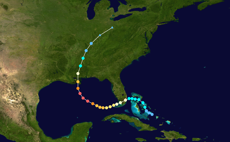
Hurricane Katrina formed over the Bahamas on August 23, 2005 and crossed southern Florida as a moderate Category 1 hurricane, causing some deaths and flooding there before strengthening rapidly in the Gulf of Mexico. The hurricane strengthened to a Category 5 hurricane over the warm Gulf water, but weakened before making its second landfall as a Category 3 hurricane on the morning of Monday, August 29 in southeast Louisiana. It caused severe destruction along the Gulf coast from central Florida to Texas, much of it due to the storm surge. The most significant number of deaths occurred inNew Orleans, Louisiana, which flooded as the levee system catastrophically failed, in many cases hours after the storm had moved inland.[5] Eventually 80% of the city and large tracts of neighboringparishes became flooded, and the floodwaters lingered for weeks.[5] However, the worst property damage occurred in coastal areas, such as all Mississippi beachfront towns, which were flooded over 90% in hours, as boats and casino barges rammed buildings, pushing cars and houses inland, with waters reaching 6–12 miles (10–19 km) from the beach.Hurricane Katrina was the deadliest and most destructive Atlantic hurricane of the 2005 Atlantic hurricane season. It was the costliest natural disaster, as well as one of the five deadliest hurricanes, in the history of the United States.[3] Among recorded Atlantic hurricanes, it was the sixth strongest overall. At least 1,833 people died in the hurricane and subsequent floods, making it the deadliest U.S. hurricane since the 1928 Okeechobee hurricane; total property damage was estimated at $81 billion (2005 USD),[3] nearly triple the damage brought by Hurricane Andrew in 1992.[4]
The hurricane surge protection failures in New Orleans are considered the worst civil engineering disaster in U.S. history[6] and prompted a lawsuit against the U.S. Army Corps of Engineers (USACE), the designers and builders of the levee system as mandated by the Flood Control Act of 1965. Responsibility for the failures and flooding was laid squarely on the Army Corps in January 2008 by Judge Stanwood Duval, U.S. District Court,[7] but the federal agency could not be held financially liable due to sovereign immunity in the Flood Control Act of 1928. There was also an investigation of the responses from federal, state and local governments, resulting in the resignation of Federal Emergency Management Agency (FEMA) director Michael D. Brown, and of New Orleans Police Department(NOPD) Superintendent Eddie Compass.
Several agencies including the United States Coast Guard (USCG), National Hurricane Center (NHC), and National Weather Service (NWS) were commended for their actions. They provided accurate hurricane weather tracking forecasts with sufficient lead time.[8] Unfortunately, even the most insistent appeals from national, state and local public officials to residents to evacuate before the storm did not warn that the levees could breach and fail
New Orleans Hurricane of 1915 (THE OLD)
New Orleans Hurricane of 1915 (THE OLD)
KATRINA (THE NEW)
The storm rapidly intensified after entering the Gulf, growing from a Category 3 hurricane to a Category 5 hurricane in just nine hours. This rapid growth was due to the storm's movement over the "unusually warm" waters of the Loop Current, which increased wind speeds.[10] On Saturday, August 27, the storm reached Category 3 intensity on theSaffir-Simpson Hurricane Scale, becoming the third major hurricane of the season. An eyewall replacement cycledisrupted the intensification, but caused the storm to nearly double in size. Katrina again rapidly intensified, attaining Category 5 status on the morning of August 28 and reached its peak strength at 1800 UTC that day, with maximum sustained winds of 175 mph (280 km/h) and a minimum central pressure of 902 mbar (26.6 inHg). The pressure measurement made Katrina the fourth most intense Atlantic hurricane on record at the time, only to be surpassed by Hurricanes Rita and Wilma later in the season; it was also the strongest hurricane ever recorded in the Gulf of Mexico at the time. However, this record was later broken by Hurricane Rita.[3]
The storm rapidly intensified after entering the Gulf, growing from a Category 3 hurricane to a Category 5 hurricane in just nine hours. This rapid growth was due to the storm's movement over the "unusually warm" waters of the Loop Current, which increased wind speeds.[10] On Saturday, August 27, the storm reached Category 3 intensity on theSaffir-Simpson Hurricane Scale, becoming the third major hurricane of the season. An eyewall replacement cycledisrupted the intensification, but caused the storm to nearly double in size. Katrina again rapidly intensified, attaining Category 5 status on the morning of August 28 and reached its peak strength at 1800 UTC that day, with maximum sustained winds of 175 mph (280 km/h) and a minimum central pressure of 902 mbar (26.6 inHg). The pressure measurement made Katrina the fourth most intense Atlantic hurricane on record at the time, only to be surpassed by Hurricanes Rita and Wilma later in the season; it was also the strongest hurricane ever recorded in the Gulf of Mexico at the time. However, this record was later broken by Hurricane Rita.[3]

Katrina made its second landfall at 1110 UTC (6:10 a.m. CDT) on Monday, August 29 as a Category 3 hurricane with sustained winds of 125 mph (205 km/h) near Buras-Triumph, Louisiana. At landfall, hurricane-force winds extended outward 120 miles (190 km) from the center and the storm's central pressure was 920 mbar (27 inHg). After moving over southeastern Louisiana and Breton Sound, it made its third landfall near the Louisiana/Mississippi border with 120 mph (195 km/h) sustained winds, still at Category 3 intensity. Katrina maintained strength well into Mississippi, finally losing hurricane strength more than 150 miles (240 km) inland near Meridian, Mississippi. It was downgraded to a tropical depression near Clarksville, Tennessee, but its remnants were last distinguishable in the eastern Great Lakes region on August 31, when it was absorbed by a frontal boundary. The resulting extratropicalstorm moved rapidly to the northeast and affected eastern Canada
On Sunday, August 28, as the sheer size of Katrina became clear, the NHC extended the tropical storm warning zone to cover most of the Louisiana coastline and a larger portion of the Florida Panhandle. The National Weather Service's New Orleans/Baton Rouge office issued a vividly worded bulletin predicting that the area would be "uninhabitable for weeks" after "devastating damage" caused by Katrina, which at that time rivaled the intensity of Hurricane Camille.[18] "On Sunday, August 28, President Bush spoke with Governor Blanco to encourage her to order a mandatory evacuation of New Orleans." (Per page 235 of Special Report of the Committee on Homeland Security and Governmental Affairs)[19]
Voluntary and mandatory evacuations were issued for large areas of southeast Louisiana as well as coastal Mississippi and Alabama. About 1.2 million residents of the Gulf Coast were covered under a voluntary or mandatory evacuation order
Investigation of State of Emergency declaration
In a September 26, 2005 hearing, former FEMA chief Michael Brown testified before a U.S. House subcommittee about FEMA's response. During that hearing, Representative Stephen Buyer (R-IN) inquired as to why President Bush's declaration of state of emergency of August 27 had not included the coastal parishes of Orleans, Jefferson, and Plaquemines.[20] (In fact, the declaration did not include any of Louisiana's coastal parishes, whereas the coastal counties were included in the declarations for Mississippi[21] and Alabama.[22]) Brown testified that this was because Louisiana Governor Blanco had not included those parishes in her initial request for aid, a decision that he found "shocking." After the hearing, Blanco released a copy of her letter, which showed she had requested assistance for "all the southeastern parishes including the City of New Orleans" as well specifically naming 14 parishes including Jefferson, Orleans and Plaquemines.

Vertical cross-section of New Orleans, showing maximum levee height of 23 feet (7 m). Vertical scale exaggerated.
City of New Orleans
By August 26, the possibility of unprecedented cataclysm was already being considered. Many of the computer models had shifted the potential path of Katrina 150 miles (240 km) westward from the Florida Panhandle, putting the city of New Orleans directly in the center of their track probabilities; the chances of a direct hit were forecast at 17%, with strike probability rising to 29% by August 28.[31] This scenario was considered a potential catastrophe because some parts of New Orleans and the metro area are below sea level. Since the storm surge produced by the hurricane's right-front quadrant (containing the strongest winds) was forecast to be 28 feet (8.5 m), emergency management officials in New Orleans feared that the storm surge could go over the tops of levees protecting the city, causing major flooding.[32]
At a news conference at 10 am on August 28, shortly after Katrina was upgraded to a Category 5 storm, New Orleans mayor Ray Nagin ordered the first-ever mandatory evacuation of the city, calling Katrina "a storm that most of us have long feared."[33] The city government also established several "refuges of last resort" for citizens who could not leave the city, including the massive Louisiana Superdome, which sheltered approximately 26,000 people and provided them with food and water for several days as the storm came ashoreOn August 29, Katrina's storm surge caused 53 different levee breaches in greater New Orleans, submerging eighty percent of the city. A June 2007 report by the American Society of Civil Engineers indicated that two-thirds of the flooding were caused by the multiple failures of the city's floodwalls.[38] Not mentioned were the flood gates that were not closed.[citation needed] The storm surge also devastated the coasts of Mississippi and Alabama, making Katrina the most destructive and costliest natural disaster in the history of the United States, and the deadliest hurricane since the 1928 Okeechobee Hurricane. The total damage from Katrina is estimated at $81.2 billion (2005 U.S. dollars), nearly double the cost of the previously most expensive storm,Hurricane Andrew, when adjusted for inflation.[3][39]Impact
The confirmed death toll (total of direct and indirect deaths) is 1,836, mainly from Louisiana (1,577) and Mississippi (238).[37][40] However, 135 people remain categorized as missing in Louisiana,[37] and many of the deaths are indirect, but it is almost impossible to determine the exact cause of some of the fatalities.
Federal disaster declarations covered 90,000 square miles (233,000 km2) of the United States, an area almost as large as the United Kingdom. The hurricane left an estimated three million people without electricity. On September 3, 2005, Homeland Security Secretary Michael Chertoff described the aftermath of Hurricane Katrina as "probably the worst catastrophe, or set of catastrophes," in the country's history, referring to the hurricane itself plus the flooding of New Orleans.[41]
Louisiana

On August 29, Hurricane Katrina made landfall near Buras-Triumph, Louisiana with 125 mph (205 km/h) winds, as a strong Category 3 storm. However, as it had only just weakened from Category 4 strength and the radius of maximum winds was large, it is possible that sustained winds of Category 4 strength briefly impacted extreme southeastern Louisiana. Although the storm surge to the east of the path of the eye in Mississippi was higher, a very significant surge affected the Louisiana coast. The height of the surge is uncertain because of a lack of data, although a tide gauge in Plaquemines Parish indicated a storm tide in excess of 14 feet (4.3 m) and a 12-foot (3 m) storm surge was recorded in Grand Isle. Hurricane Katrina made final landfall near the mouth of the Pearl River, with the eye straddling St. Tammany Parish, Louisiana and Hancock County, Mississippi, on the morning of August 29 at about 9:45M CST.[3]
Hurricane Katrina also brought heavy rain to Louisiana, with 8 – 10 inches (200 – 250 mm) falling on a wide swath of the eastern part of the state. In the area around Slidell, the rainfall was even higher, and the highest rainfall recorded in the state was approximately 15 inches (380 mm). As a result of the rainfall and storm surge the level of Lake Pontchartrain rose and caused significant flooding along its northeastern shore, affecting communities from Slidell to Mandeville. Several bridges were destroyed, including the I-10 Twin Span Bridgeconnecting Slidell to New Orleans.[3] Almost 900,000 people in Louisiana lost power as a result of Hurricane Katrina.[45]
Katrina’s storm surge inundated all parishes surrounding Lake Pontchartrain, including St. Tammany, Tangipahoa, St. John the Baptist and St. Charles Parishes. St. Tammany Parish received a two-part storm surge. The first surge came as Lake Pontchartrain rose and the storm blew water from the Gulf of Mexico into the lake. The second came as the eye of Katrina passed, westerly winds pushed water into a bottleneck at the Rigolets Pass, forcing it farther inland. The range of surge levels in eastern St. Tammany Parish is estimated at 13 to 16 feet (4.9 m), not including wave action.[46]
Hard-hit St. Bernard Parish was flooded due to breaching of the levees that contained a navigation channel called the Mississippi River Gulf Outlet (MR-GO) and the breach of the Levee Board designed and built 40 Arpent canal levee. The search for the missing was undertaken by the St. Bernard Fire Department due to the assets of the United States Coast Guard being diverted to New Orleans. Many of the missing in the months after the storm were tracked down by searching flooded homes, tracking credit card records, and visiting homes of family and relatives.[47]

According to the U.S. Dept. of Housing and Urban Development, in St. Bernard Parish, 81% (20,229) of the housing units were damaged. In St. Tammany Parish, 70% (48,792) were damaged and in Placquemines Parish 80% (7,212) were damaged.[48]
In addition, the combined effect of Hurricanes Katrina and Rita was the destruction of an estimated 562 square kilometres (217 sq mi) of coastal wetlands in Louisiana.[49]
New Orleans

As the eye of Hurricane Katrina swept to the northeast, it subjected the city to hurricane conditions for hours. Although power failures prevented accurate measurement of wind speeds in New Orleans, there were a few measurements of hurricane-force winds. From this the NHC concluded that it is likely that much of the city experienced sustained winds of Category 1 or Category 2 strength.
Katrina's storm surge led to 53 levee breaches in the federally built levee system protecting metro New Orleans and the failure of the 40 Arpent Canal levee. Nearly every levee in metro New Orleans was breached as Hurricane Katrina passed just east of the city limits. Failures occurred in New Orleans and surrounding communities, especially St. Bernard Parish. The Mississippi River Gulf Outlet (MR-GO) breached its levees in approximately 20 places, flooding much of east New Orleans, most of Saint Bernard Parish and the East Bank of Plaquemines Parish. The major levee breaches in the city included breaches at the 17th Street Canal levee, the London Avenue Canal, and the wide, navigable Industrial Canal, which left approximately 80% of the city flooded.[50]
Most of the major roads traveling into and out of the city were damaged. The only routes out of the city were the westbound Crescent City Connection and the Huey P. Long Bridge, as large portions of the I-10 Twin Span Bridge traveling eastbound towards Slidell, Louisiana had collapsed. Both the Lake Pontchartrain Causeway and the Crescent City Connection only carried emergency traffic.[51]
On August 29, at 7:40 am CDT, it was reported that most of the windows on the north side of the Hyatt Regency New Orleans had been blown out, and many other high rise buildings had extensive window damage.[52] TheHyatt was the most severely damaged hotel in the city, with beds reported to be flying out of the windows. Insulation tubes were exposed as the hotel's glass exterior was completely sheared off.[53]

The Superdome, which was sheltering many people who had not evacuated, sustained significant damage.[54]Two sections of the Superdome's roof were compromised and the dome's waterproof membrane had essentially been peeled off. Louis Armstrong New Orleans International Airport was closed before the storm but did not flood. On August 30, it was reopened to humanitarian and rescue operations. Limited commercial passenger service resumed at the airport on September 13 and regular carrier operations resumed in early October.[55]
Levee breaches in New Orleans also caused a significant amount of deaths, with over 700 bodies recovered in New Orleans by October 23, 2005.[56] Some survivors and evacuees reported seeing dead bodies lying in city streets and floating in still-flooded sections, especially in the east of the city. The advanced state of decomposition of many corpses, some of which were left in the water or sun for days before being collected, hindered efforts by coroners to identify many of the dead.[57]
The first deaths reported from the city were reported shortly before midnight on August 28, as threenursing home patients died during an evacuation to Baton Rouge, most likely from dehydration. While there were also early reports of fatalities amid mayhem at the Superdome, only six deaths were confirmed there, with four of these originating fromnatural causes, one from a drug overdose, and one a suicide. At the Convention Center, four bodies were recovered. One of the four is believed to be the result of a homicide.[58]
There is evidence that many prisoners were abandoned in their cells during the storm, while the guards sought shelter. Hundreds of prisoners were later registered as "unaccounted for"
Economic effects
| ||||||||||||||||||||||||||||||||||||||||||||||||||
The economic effects of the storm were far-reaching. The Bush Administration sought $105 billion for repairs and reconstruction in the region,[78] which did not account for damage to the economy caused by potential interruption of the oil supply, destruction of the Gulf Coast's highway infrastructure, and exports of commodities such as grain. Katrina damaged or destroyed 30 oil platforms and caused the closure of nine refineries;[39] the total shut-in oil production from the Gulf of Mexico in the six-month period following Katrina was approximately 24% of the annual production and the shut-in gas production for the same period was about 18%.[79] The forestry industry in Mississippi was also affected, as 1.3 million acres (5,300 km2) of forest lands were destroyed.[80] The total loss to the forestry industry from Katrina is calculated to rise to about $5 billion.[80] Furthermore, hundreds of thousands of local residents were left unemployed, which will have a trickle-down effect as fewer taxes are paid to local governments. Before the hurricane, the region supported approximately one million non-farm jobs, with 600,000 of them in New Orleans. It is estimated that the total economic impact in Louisiana and Mississippi may exceed $150 billion.[81]
Katrina redistributed over one million people from the central Gulf coast elsewhere across the United States, which became the largest diaspora in the history of the United States.[82] Houston, Texas, had an increase of 35,000 people; Mobile, Alabama, gained over 24,000; Baton Rouge, Louisiana, over 15,000; and Hammond, Louisiana received over 10,000, nearly doubling its size. Chicago received over 6,000 people, the most of any non-southern city.[83] By late January 2006, about 200,000 people were once again living in New Orleans, less than half of the pre-storm population.[84] By July 1, 2006, when new population estimates were calculated by the U.S. Census Bureau, the state of Louisiana showed a population decline of 219,563, or 4.87%.[85] Additionally, some insurance companies have stopped insuring homeowners in the area because of the high costs from Hurricanes Katrina and Rita, or have raised homeowners' insurance premiums to cover their risk
Environmental effects

Katrina also had a profound impact on the environment. The storm surge caused substantial beach erosion, in some cases completely devastating coastal areas. In Dauphin Island, approximately 90 miles (150 km) to the east of the point where the hurricane made landfall, the sand that comprised the barrier island was transported across the island into the Mississippi Sound, pushing the island towards land.[87]The storm surge and waves from Katrina also obliterated the Chandeleur Islands, which had been affected by Hurricane Ivan the previous year.[88] The US Geological Survey has estimated 217 square miles (560 km2) of land was transformed to water by the hurricanes Katrina and Rita.[89]
The lands that were lost were breeding grounds for marine mammals, brown pelicans, turtles, and fish, as well as migratory species such as redhead ducks.[80] Overall, about 20% of the local marshes were permanently overrun by water as a result of the storm.[80]
The damage from Katrina forced the closure of 16 National Wildlife Refuges. Breton National Wildlife Refuge lost half its area in the storm.[90] As a result, the hurricane affected the habitats of sea turtles, Mississippi sandhill cranes, Red-cockaded woodpeckers and Alabama Beach mice.[90]
| Large oil spills caused by Hurricane Katrina Spills exceeding 10,000 US gallons (38,000 L)[91] | ||
|---|---|---|
| Spill Location | Quantity | |
| (US gal) | (L) | |
| Bass Enterprises (Cox Bay) | 3,780,000 | 14,300,000 |
| Shell (Pilot Town) | 1,050,000 | 4,000,000 |
| Chevron (Empire) | 991,000 | 3,750,000 |
| Murphy Oil (Meraux and Chalmette) | 819,000 | 3,100,000 |
| Bass Enterprises (Pointe à la Hache) | 461,000 | 1,750,000 |
| Chevron (Port Fourchon) | 53,000 | 200,000 |
| Venice Energy Services (Venice) | 25,000 | 95,000 |
| Shell Pipeline Oil (Nairn) | 13,440 | 50,900 |
| Sundown Energy (West Potash) | 13,000 | 49,000 |
The storm caused oil spills from 44 facilities throughout southeastern Louisiana, which resulted in over 7 million U.S. gallons (26 million L) of oil being leaked. Some spills were as small as a few hundred gallons; the largest are tabulated to the right. While most of the spills were contained on-site, some oil entered the ecosystem, and the town of Meraux was flooded with a blend of water and oil.[91] Unlike Hurricane Ivan no offshore oil spills were officially reported after Hurricane Katrina. However, Skytruth reported some signs of surface oil in the Gulf of Mexico.[91]
Finally, as part of the cleanup effort, the flood waters that covered New Orleans were pumped into Lake Pontchartrain, a process that took 43 days to complete.[39] These residual waters contained a mix of raw sewage, bacteria, heavy metals, pesticides, toxic chemicals, and oil, which sparked fears in the scientific community of massive numbers of fish dying.[80]
Prior to the storm, subsidence and erosion caused erosion in the Louisiana wetlands and bayous. This, along with the canals built in the area, allowed for Katrina to maintain more of its intensity when it struck.[92]
PLEASE see link for remaining article.
http://www.youtube.com/watch?v=2pX6hrYRnYk
Hurricane Camille
From Wikipedia, the free encyclopedia
http://en.wikipedia.org/wiki/Hurricane_Camille

Comparisons to Hurricane Katrina
Although Hurricane Camille and Hurricane Katrina took different paths, they both reached the same section of the coast of Mississippi with similar destructive effects. Camille intensified more rapidly than Katrina, and unlike Katrina, Camille maintained status as a Category 5 hurricane until landfall. However, the observed minimum pressure in Katrina was slightly lower. Both hurricanes shared the common aspect of undergoing periods of rapid intensification.[45] The size of Camille's radius of maximum wind was less than one-third that of Katrina, more similar to the intense but smallHurricane Andrew. Also unlike Katrina, Camille caused little damage in New Orleans, Louisiana, though Camille itself just barely missed the city.[46] The area of hurricane-force winds within Camille was just over two-thirds the size of Hurricane Katrina. Both storms were moving at a similar forward motion at the time of landfall. Although Camille's wind speed at landfall was higher, Katrina's storm surge exceeded Camille's storm surge at all known locations due to its greater size.[47] Both hurricanes' names were retired.
http://pontchartrain.net/495429
September 11, 1722 First Recorded Hurricane
Although it was nine years before a permanent church was built, Christians living in New Orleans did have an opportunity to attend religious services. The first temporary place of worship was located on St. Ann Street. It was a makeshift half warehouse, half chapel.
On Sept. 11, 1722, the first recorded hurricane struck New Orleans. The storm played havoc with the area. Every building in the new city was destroyed, including the building housing the temporary chapel. The winds were so strong three large vessels that lay in the Mississippi River were blown on shore.
Source: Buddy Stall at http://clarionherald.org/20000511/stall.htm
http://www.youtube.com/watch?v=vmx2wSVT5i0On Sept. 11, 1722, the first recorded hurricane struck New Orleans. The storm played havoc with the area. Every building in the new city was destroyed, including the building housing the temporary chapel. The winds were so strong three large vessels that lay in the Mississippi River were blown on shore.
Source: Buddy Stall at http://clarionherald.org/20000511/stall.htm
New Orleans Hurricane of 1915
1915 New Orleans hurricane
From Wikipedia, the free encyclopedia
| Category 4 hurricane (SSHS) | |
|---|---|
 | |
| Smashed streetcar barn, New Orleans | |
| Formed | September 21, 1915 |
| Dissipated | October 1, 1915 |
| Highest winds | 1-minute sustained: 145 mph (230 km/h) |
| Lowest pressure | 931 mbar (hPa); 27.49 inHg |
| Fatalities | 275-279 |
| Damage | $13 million (1915 USD) |
New Orleans
In New Orleans winds of 50 miles per hour (80 km/h) reached the city at 7am, climbing to 60 miles (97 km) an hour over the next 5 hours. Hurricane conditions were experienced from the afternoon into the night, with steady winds of 102 mph (164 km/h) and gusts up to 130 mph (210 km/h). There were reports of damage in New Orleans, with roofs blown off buildings and the Presbytère on Jackson Square losing its cupola. The clock on St. Louis Cathedral stopped at 5:50pm, the height of the storm. The hurricane damaged the Times-Picayune building, hampering newspaper production. More church steeples in the city were blown down or significantly damaged than remained intact.
Only 21 of the storm-related deaths were within the city.The landmark Presbyterian Church on Lafayette Square collapsed, as did St. Anna's Episcopal Church on Esplanade Avenue. Half the rides at Spanish Fort were destroyed. Horticultural Hall in Audubon Parkwas destroyed. Wind damage was worse than the most recent previous hurricane to hit the city in 1909, but flooding was much less widespread; however, there were reports of waters from Lake Pontchartrain being forced backwards into the city's drainage canals by the storm, an event which would be repeated more catastrophically with Hurricane Katrina 90 years later. After power to drainage pumps failed, parts of the Mid-City neighborhood suffered significant flooding.

First Presbyterian Church on Lafayette Square, destroyed by the great hurricane of 1915, collapsing at 5:02pm
http://www.youtube.com/watch?v=NXJQOWsp6f4
http://www.youtube.com/watch?v=oilm-OoR8KM
Uploaded on Jan 15, 2012
I Put a Spell on You-Lyrics:
I put a spell on you
Because you're mine.
You better stop
The things that you're doin'.
I said "Watch out!
I ain't lyin',
yeah!
I ain't gonna take none of your
Foolin' around,
I ain't gonna take none of your
Puttin' me down,
I put a spell on you
Because you're mine.
All right!
I put a spell on you
Because you're mine.
You better stop
The things that you're doin'.
I said "Watch out!
I ain't lyin',
yeah!
I ain't gonna take none of your
Foolin' around,
I ain't gonna take none of your
Puttin' me down,
I put a spell on you
Because you're mine.
All right!
I put a spell on you
Because you're mine.
You better stop
The things that you're doin'.
I said "Watch out!
I ain't lyin',
yeah!
I ain't gonna take none of your
Foolin' around,
I ain't gonna take none of your
Puttin' me down,
I put a spell on you
Because you're mine.
All right!
Creedence Clearwater Revival:
John Fogerty-Vocals, Lead Guitar
Tom Fogerty-Guitar
Stu Cook-Bass
Doug Clifford-Drums
O+O
No comments:
Post a Comment
Hi Everybody! Please say hello and follow so I know you are here! Due to the inconsideration of people trying to put commercials on my blog comment area, I have restricted use of anonymous posts. Sorry that some hurt all.
My public email is katescabin@gmail.com No spammers or trolls